| | Thumbnail | | Creator | Date | Title / Author / Date / Location | Price | | | Description |
| 5178 | 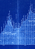 | Details | Canadian Pacific Railroad | 1915 |
| Cyanotype transcontinental elevation profile for Canadian Pacific Railroad |
|
Canadian Pacific Railroad |
|
| 1915 |
| LOC:62 |
| $0.00 | Canadian-Pacific-Railroad | Cyanotype-transcontinental-elevation-profile-for-Canadian-Pacific-Railroad | SOLD
<br></br>
Fascinating cyanotype, or blueprint, transcontinental elevation profile for the Canadian Pacific Railroad (CPR) ca. 1915. Shows the elevation of the CPR line stretching Montreal (bottom right) to Vancouver, Canada (top left). At a horizontal scale of 1" = 30 miles and vertical scale of 1" = 1000 feet the chart clearly represents the vast distance across Canada as well as the challenges imposed by the Rocky Mountains and the Selkirk Mountain Range.
<br></br>
Date was obtained by analysis of the profile at Rogers Pass on the Selkirk Range where a tunnel is shown under construction. The tunnel at that point fits the Connaught Tunnel which was built to replace the route over Roger's Pass. The Connaught Tunnel is known to have been under construction from April 2, 1914 until December 16, 1916 when it began operational service. |
| 5019 | 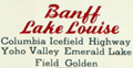 | Details | Canadian Pacific Railroad | 1941 |
| Map of Banff Lake Louise Columbia Icefield Highway Glaciers |
|
Canadian Pacific Railroad |
|
| 1941 |
| LOC:10 |
| $350.00 | Canadian-Pacific-Railroad | Map-of-Banff-Lake-Louise-Columbia-Icefield-Highway-Glaciers | Attractive and very scarce lithographed map of Banff, Lake Louise and the Columbia Icefield Highway with the Yoho Valley Emerald Lake Field, and Golden, Canada. Shows highways, glaciers, mountain ranges, trails, and the route of the Canadian Pacific Railway.
<br></br>
Map is on the recto of a folding six-part brochure with an inset elevation view of the "Altitudes of principal peaks from Golden to Banff in the Canadian Rockies." In that view the peaks with names underlined are on the South Side of the Canadian Pacific Railway main line from Banff to Golden.
<br></br>
Verso contains photographs, text and a map of the Columbia Icefield Highway (Sunwapta Pass to Lake Louise) and a cross section (elevation view) of the Canadian Rockies from the same Columbia Icefield Highway. Dated by reference to the Rumsey Collection. |