| | Thumbnail | | Creator | Date | Title / Author / Date / Location | Price | | | Description |
| 8051 | 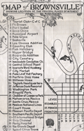 | Details | Cole, C. C. | 1929 |
| Scarce early tourists map of Brownsville Texas |
|
Cole, C. C. |
|
| 1929 |
| LOC:13 |
| $150.00 | Cole--C--C- | Scarce-early-tourists-map-of-Brownsville-Texas | This pictorial tourist map, drawn by C. C. Cole ca. 1929, presents Brownsville, Texas as a civic and recreational destination, combining a rectilinear street grid with illustrated landmarks, river scenery, and playful vignettes of fishing, boating, and wildlife along the Rio Grande and resaca waterways (1). Key sites are keyed in a numbered legend and include Fort Brown, the municipal airport, parks, cemeteries, schools, churches, rail depots, and cross border connections to Matamoros and Santa Cruz, Mexico. Produced in a hand drawn, chamber of commerce style, the map emphasizes accessibility, leisure, and modern amenities while still foregrounding the river, levees, and ship channel that defined Brownsville’s geographic and economic setting.<br><br> The map can be dated to the late 1920s, most plausibly around 1929, based on multiple internal clues. The inclusion of a municipal airport places it no earlier than the late 1920s, while the continued identification of Fort Brown with the 12th Cavalry reflects a period before the post cavalry drawdowns of the early 1930s. References such as Mexican National Lines, the Porfirio Diaz home as a tourist landmark, and the absence of later port and industrial expansions further support a pre 1930s context. The overall booster tone, pictorial style, and civic focus are consistent with chamber of commerce tourist maps produced during the interwar years, pointing to a narrow window just before the Great Depression reshaped local promotion and infrastructure. |