| | Thumbnail | | Creator | Date | Title / Author / Date / Location | Price | | | Description |
| 1354 | 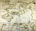 | Details | Collins, Greenvile | 1750 |
| Antique Chart of the Chief Ports of the British Isles |
|
Collins, Greenvile |
|
| 1750 |
| LOC:64 |
| $180.00 | Collins--Greenvile | Antique-Chart-of-the-Chief-Ports-of-the-British-Isles | Antique nautical chart by Collins of seven key ports and harbors in England. These important English locations were dominated by the <b>Thames River</b> with Greenwich, Deptford, and finally upriver- London. Other insets are included for:
<div class="indenttextblock">
<ul style="list-style-type: circle;">
<li>Isle of Wight and Portsmouth</li>
<li>Plimouth Sound [Plymouth]</li>
<li>Portland Bill</li>
<li>Road and Harbour of Dartmouth</li>
<li>Falmouth Harbour</li>
</ul>
</div>
An attractive eighteenth-century engraved nautical chart, with an authentic sea-worn appearance, printed ca. 1750.
<br></br>
From Captain Greenville or Greenvile Collins "Great Britain's Coasting Pilot: being a new and exact survey of the sea-coast of England and Scotland from the river of Thames to the westward and northward ...".
<br></br> |
| 1316 | 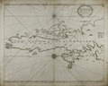 | Details | Collins, Greenvile | 1750 |
| Antique Chart of the South Shetland Islands |
|
Collins, Greenvile |
|
| 1750 |
| LOC:0 |
| $240.00 | Collins--Greenvile | Antique-Chart-of-the-South-Shetland-Islands | Old engraved antique sea chart of the southern portion of the <b>Shetland Islands</b>, a part of Scotland. Includes the islands of Tronzo, Nebra, West Buro, Bressay (Brassey) and Noss (Nos). Inset chart of Catford Roe with soundings and anchorages noted.
<br></br>
A decorative antique eighteenth century copperplate nautical sea chart, with an authentic sea-worn appearance, printed on thick paper ca. 1750.
<br></br>
From Captain Greenville or Greenvile Collins "Great Britain's Coasting Pilot: being a new and exact survey of the sea-coast of England and Scotland from the river of Thames to the westward and northward ...".
<br></br>
Greenville Collins was an officer of the Royal Navy and prominent hydrographer who was commissioned by King Charles II in 1676 and appointed by Samuel Pepys to chart the coasts of Great Britain. The resulting atlas - Great Britain's Coasting Pilot - was the first original sea atlas to be produced by an Englishman. |
| 1287 | 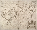 | Details | Collins, Greenvile | 1750 |
| Antique Chart of the Shetland Islands |
|
Collins, Greenvile |
|
| 1750 |
| LOC:0 |
| $156.00 | Collins--Greenvile | Antique-Chart-of-the-Shetland-Islands | Antique sea chart of the eastern portion of the <b>Shetland island of the "Mainland"</b>, a part of Scotland. Includes the islands of Bressay (Brassey) and Noss (Nos). Noted are the villages of Lerwick, Heoghan, Laxford and many more.
<br></br>
Decorative antique eighteenth century copperplate nautical sea chart, printed on thick paper ca. 1750. Attribution for engraving at bottom left to "H. Moll"- Herman Moll.
<br></br>
From Captain Greenville or Greenvile Collins "Great Britain's Coasting Pilot: being a new and exact survey of the sea-coast of England and Scotland from the river of Thames to the westward and northward ...".
<br></br>
Greenville Collins was an officer of the Royal Navy and prominent hydrographer who was commissioned by King Charles II in 1676 and appointed by Samuel Pepys to chart the coasts of Great Britain. The resulting atlas - Great Britain's Coasting Pilot - was the first original sea atlas to be produced by an Englishman. |
| 825 | 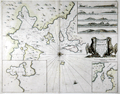 | Details | Collins, Greenvile | 1750 |
| Antique nautical chart of the Orkney Islands |
|
Collins, Greenvile |
|
| 1750 |
| LOC:57 |
| $550.00 | Collins--Greenvile | Antique-nautical-chart-of-the-Orkney-Islands | Antique sea chart of the North Sea, the Orkney Islands, Wide Firth, Hoy Sound and Deer Sound. The islands shown on this scarce, old British chart include parts of the Mainland ("Pomona"), Shapinsay, Gairsay, Wyre, Egilsay, and Rousay. With 5 coastal elevation views including: Copinsha to Mulhead; Faire Isle; the Maiden Papps of Carness; Dunkins Bay Head.
<br></br>
Title cartouche on this decorative chart of the Orkneys is held up by a pair of fierce sea eagles clutching a rag between their beaks. <div class="indenttextblock">Sea eagles have a long history in Orkney. The Bronze Age burial tomb at Isbister, South Ronaldsay (the ‘Tomb of the Eagles’) famously contains their bones, while a Pictish symbol stone found at the Knowe of Burrian, Harray, features a beautifully carved bird.
<br></br>
Sea eagles became extinct across the UK in the early 19th century due to combination of widespread habitat loss and human persecution, with the last bird shot in Shetland in 1918. (<b>Sea Eagles Nest in Orkney after 142-year Absence</b>". Royal Society for the Protection of Birds. <a href="http://www.rspb.org.uk/community/placestovisit/orkney/b/orkney-blog/archive/2015/04/16/sea-eagles-nest-in-orkney-after-142-year-absence.aspx">Internet.</a> June 19, 2015)</div>
</br>
Date in the title cartouche was largely erased from the copper engraving plate but remains faintly visible as 1688. This sheet is probably a later edition (estimated 1750), explaining the erasure. From one of the many editions of Greenville Collin's 'Great Britain's Coasting Pilot', published from 1693 to 1792. |
| 116 |  | Details | Collins, Greenvile | 1750 |
| How the Several Lands Show at Sea |
|
Collins, Greenvile |
|
| 1750 |
| LOC:0 |
| $135.00 | Collins--Greenvile | How-the-Several-Lands-Show-at-Sea | Antique nautical profile views of English coast including Beachy Head, Portland, Isle of Wight, Dartmouth, and Milford. This scarce nautical engraving accompanied other nautical charts from one of the many editions of Great Britain's Coasting Pilot by Greenville Collins. |
| 370 |  | Details | Collins, Greenvile | 1750 |
| Rye |
|
Collins, Greenvile |
|
| 1750 |
| LOC:0 |
| | Collins--Greenvile | Rye | This item is sold but please see this
<a href="http://www.rarecharts.com/ShowDetail/Creator/Sayer--Robert/Title/Antique-nautical-chart-of-the-Harbor-of-Rye-in-Sussex--England/780">very similar harbor chart of Rye by Robert Sayer.</a>
<br></br>
Chart depicts the coast of Kent and towns of Rye and Socket England along with the Rye Camber and part of the Romney Marshes. This chart by Greenville Collins was published between 1750 and 1790 and shows the navigational channel to Rye marked by beacons as well as numerous soundings at high and low water. <BR> </BR>
Dedicatory cartouche in upper right with putti contains the dedication: "To the Honorable Robert Austen, Esq One of the Lords Commissioners for Executing the Office of Lord High Admiral of England This Map is most Humbly dedicated and Presented by Captain Greenville Collins." With a decorative square-rigged warship and a colorful compass rose. Number 8. |
| 842 | 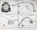 | Details | Collins, Greenvile | 1750 |
| Antique chart of coastal England with Bridlington, Scarborough and Hartlepoole |
|
Collins, Greenvile |
|
| 1750 |
| LOC:0 |
| $240.00 | Collins--Greenvile | Antique-chart-of-coastal-England-with-Bridlington--Scarborough-and-Hartlepoole | Three antique charts of ports on the Yorkshire and Durham coasts of England, including Bridlington ( Burlington ) , Scarborough and Hartlepoole. Coastal areas around these three English ports on the eastern coast of England were important to mid 18th century navigators. The approach to Bridlington in particular would have been particularly hazardous without an accurate chart because of an offshore sandbar ( "Smithic Sand" ) and the nearby promontory of Flamborough Head. The lighthouse shown at Flamborough Head was constructed in 1669 by Sir John Clayton. The current lighthouse dates to 1806.
<br></br>
Dedicated to Captain Ralph Sanderson. From one of the many editions of Greenville Collin's 'Great Britain's Coasting Pilot', published from 1693 to 1792. Number 37. |
| 943 | 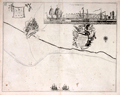 | Details | Collins, Greenvile | 1750 |
| Antique chart of the coast near Leith, Scotland |
|
Collins, Greenvile |
|
| 1750 |
| LOC:0 |
| $325.00 | Collins--Greenvile | Antique-chart-of-the-coast-near-Leith--Scotland | Antique chart of the city of <b>Leith, Scotland</b> (North and South Leith) and the surrounding coastline by <b>Greenville Collins</b>. With an attractive inset view "Prospect of Leith from the East" showing Leith Harbour, with square-rigged sailing ships anchored behind the pier. With one of the earliest available street plans of Leith, showing the bridge across the Water of Leith linking the two halves of the city. That bridge, originally built in the late 15th century, was demolished in 1780.
<br></br>
From one of the many editions of Greenville Collin's 'Great Britain's Coasting Pilot', published from 1693 to 1792. At top left angels hover holding a sheet on which is drawn a elevation view of a castle with three domed towers and three gates, each with a portcullis. Suggested by one writer to be a coat-of-arms, the actual meaning of the image is unkown. |
| 5106 | 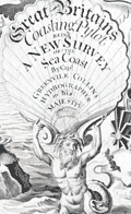 | Details | Collins, Greenvile | 1753 |
| Engraved Frontispiece for Great Britains Coasting Pilot |
|
Collins, Greenvile |
|
| 1753 |
| LOC:88 |
| $350.00 | Collins--Greenvile | Engraved-Frontispiece-for-Great-Britains-Coasting-Pilot | Fine original engraved frontispiece for "Great Britains Coasting Pylot being a new survey of the sea coast by Greenvile Collins Hydrographer to His Majesty." With Poseidon, Britannia, sea nymphs, putti, trumpets, navigation instruments, a chart of the U.K. and one trident. Very attractive.
<br></br>
Sold by William Mount and Thomas Page on Tower Hill, London. |
| 1025 | 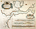 | Details | Collins, Greenvile | 1757 |
| Greenville Collins Chart of the Dart River and Dartmouth, England |
|
Collins, Greenvile |
|
| 1757 |
| LOC:0 |
| $0.00 | Collins--Greenvile | Greenville-Collins-Chart-of-the-Dart-River-and-Dartmouth--England | SOLD <br></br>Attractive, colorful antique nautical chart of the Dart River and the small village of Dartmouth along the western bank. An inset chart of Tarr Bay at top center surrounded by a leafy border. At bottom are three inset coastal elevation views of the entrance to the Dart River as seen from offshore. Notable features include Dartmouth Castle, Kingsward Castle, Old Mill Bay, Combe Point, Blackstone rock, the small village of Dittason, and Gemton Bay.
<br></br>
From one of the many editions of Greenville Collin's 'Great Britain's Coasting Pilot', published from 1693 to 1792. Captain Greenville Collins began his career as an officer in the Royal Navy. Charles II appointed Collins to the role of Hydrographer to the King in 1683 and placed him in command of the Royal yacht, Merlin. Collins was subsequently appointed by Samuel Pepys to record the coastline of Britain. The Merlin is cited as the first British warship dedicated to marine survey work. |
| 17 |  | Details | Collins, Greenvile | 1760 |
| The Isle of Man |
|
Collins, Greenvile |
|
| 1760 |
| LOC:0 |
| $0.00 | Collins--Greenvile | The-Isle-of-Man | SOLD<BR></BR>
This beautiful antique nautical chart of the Isle of Man c. 1760 is depicted with rhumb lines, soundings, an ornamental title cartouche and two sailing vessels. Features a view of Peel Castle in upper right. From one of the many editions of Greenville Collin's 'Great Britain's Coasting Pilot', published from 1693 to 1792.<BR> </BR>
Strong graphic composition and attractive subdued coloring make this nautical chart an excellent candidate for display and decoration. Inscribed: "To the Right Honorable William Earle of Derby, Lord of Ye Isle of Man & This map is humbly dedicated by Capt. G. Collins." Oriented North to right of chart. |
| 121 |  | Details | Collins, Greenvile | 1763 |
| Newcastle upon Tyne |
|
Collins, Greenvile |
|
| 1763 |
| LOC:0 |
| $0.00 | Collins--Greenvile | Newcastle-upon-Tyne | SOLD <BR> </BR>
Three hand colored charts on a single sheet of heavy wove paper. Largest section is devoted to the Tyne river from the sea to the town of Newcastle. Two inset charts continue provide additional coverage on either side of the Tyne River: one of the coast near Sunderland and the other of Blyth Harbor. <BR> </BR>
With a large dedicatory cartouche to Trinity House. Trinity House, founded under royal charter in 1514 had three primary functions: maintenance of lighthouses and other aids to navigation, pilotage authority for more than 40 ports, and was a charitable organization for mariners. This chart clearly locates daymarks and buoys, information that is often not included in charts from this period. |