| | Thumbnail | | Creator | Date | Title / Author / Date / Location | Price | | | Description |
| 598 | 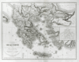 | Details | Dezauche, A.G. | 1829 |
| Carte De la Grece ou Theatre de la Guerre Entre les Grecs et les Turcs |
|
Dezauche, A.G. |
|
| 1829 |
| LOC:0 |
| $0.00 | Dezauche--A-G- | Carte-De-la-Grece-ou-Theatre-de-la-Guerre-Entre-les-Grecs-et-les-Turcs | SOLD<br></br>Antique map of Greece and Turkey with the Aegean Sea and its archipelago of islands, the Sea of Marmara, and portions of the Adriatic and Black Seas. This map is specifically focused on the "Theater of War" during the<a href="http://www.britannica.com/EBchecked/topic/244575/War-of-Greek-Independence" target="_blank"> War of Greek Independence </a> ( from Turkey ) between 1821 and 1832.
<br></br>
Specific geographical features include the Greek islands of Corfu, Crete, Rhodes, Negropont (Euboea), and Santorini; cities of Preveza, Gallipoli, Athens, Salonique ( Thessalonika ); with Smyrne ( Izmir ) and Constantinople ( Istanbul ), Turkey.
<br></br>
This large beautifully engraved, steel-plate engraved antique map was originally produced ca. 1780 by the French cartographer and former "Ingenieur-Hydrographe de la Marine" A.G. Dezauche. This edition is a published by his son J.A. Dezauche from Paris in 1829.
<br></br> |