| | Thumbnail | | Creator | Date | Title / Author / Date / Location | Price | | | Description |
| 1107 | 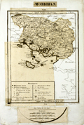 | Details | Dezauche, J.C. | 1800 |
| Unique and unusual paste up engraver's copy of an unpublished Dezauche map |
|
Dezauche, J.C. |
|
| 1800 |
| LOC:9 |
| $0.00 | Dezauche--J-C- | Unique-and-unusual-paste-up-engraver-s-copy-of-an-unpublished-Dezauche-map | SOLD<br></br>
A very unusual 216 year old paste-up map-engraver's working copy before the era of photographic reproduction. The paste-up provides a rare glimpse into the map-making thought process and the cartographic design process of the early 19th century during the French Revolution.
<br></br>
The paste-up is a composite of cut-out portions of J.C. Dezuache's "Carte Itineraire" along with fresh manuscript geographic outlines and neatlines as required. The end result of the effort is the model for a new map of only the Morbihan department with detail from the earlier Dezauche map and showing Morbihan in context with its closest neighboring areas. No record exists that this new revised map was ever published. Bears the signature and date at bottom in manuscript "Dezauche 1800".
<br></br>
In 1800 Jean-Claude Dezauche published a map of Brittany (Bretagne) and its several departments:
"Carte itinéraire de la Bretagne, contenant les départements du Finistère, du Morbihan, des Côtes-du-Nord, d'Isle-et-Vilaine et de la Loire-Inférieure, avec les routes de postes et autres routes de communications / dressée par Dezauche." It is from this map that Dezauche or his publisher extracted the bulk of the image that was to be repurposed into a new map of Morbihan. |