| | Thumbnail | | Creator | Date | Title / Author / Date / Location | Price | | | Description |
| 6698 | 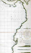 | Details | Direccion Hidrografia | 1800 |
| Rare Spanish chart of northwest South America exploration |
|
Direccion Hidrografia |
|
| 1800 |
| LOC:68 |
| $1,800.00 | Direccion-Hidrografia | Rare-Spanish-chart-of-northwest-South-America-exploration | A scarce, finely engraved original nautical chart of the northwest coast of South America from 1800. With the logo of the Deposito Hidrografico. Shows the tracks of Malaspina aboard the Descubierta and Atrevida (1). In the area of Ecuador the map is overlaid with the lines of the triangulation survey of La Condamine (2). Engraved by Fernando Selma. Dedicated to Don Antonio Cornel.
<br><br>
Shows the erupting volcano "Sangay" in Ecuador's eastern cordillera near to La Condamine's survey location.
<br><br>
(1) Malaspina Expedition - a voyage of scientific exploration sponsored by the Spanish government in the late 18th century. Led by Alejandro Malaspina the expedition set sail in 1789 with the aim of exploring and mapping the coasts of South America, Alaska, and the Philippines. The expedition included scientists, cartographers, and artists, and was one of the most extensive scientific expeditions of its time.
<br><br>
(2) Charles Marie de La Condamine was a French geographer, mathematician, and explorer who lived from 1701 to 1774. La Condamine conducted a triangulation survey near Quito, Ecuador and other locations during his expedition to South America. His goal was to measure the length of a degree of arc at the equator, which helped to confirm the shape of the Earth as an oblate spheroid. La Condamine also made important contributions to the study of Amazonian geography and culture, and he was one of the first Europeans to provide a detailed account of rubber. |
| 1324 | 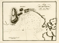 | Details | Direccion Hidrografia | 1809 |
| Antique chart of Montego Bay, Jamaica (Jamayca) |
|
Direccion Hidrografia |
|
| 1809 |
| LOC:5 |
| $600.00 | Direccion-Hidrografia | Antique-chart-of-Montego-Bay--Jamaica-(Jamayca) | Antique Spanish chart of the harbor at Montego Bay, Jamaica (Jamayca) by Spain's Direccion Hidrografia. Jamaica was a colony of Spain from 1511 until 1655, when England drove the Spanish from the island.
<BR> </BR>
Named features on this copper-plate engraved chart include:
<div class="indenttextblock">
<ul style="list-style-type: circle;">
<li>Poblacion de Barnat (Barnett Estate Plantation)</li>
<li>Rio Montego</li>
<li>Monte de Richmond</li>
<li>Punta de Fuerte Viejo (the old British fort)</li>
<li>Punta de Arenas</li>
</ul>
</div>
Published in 1809, this large-scale port/harbor chart is one of 22 charts of ports in Haiti, Dominican Republic and Jamaica (on 16 plates) published by the Spanish Admiralty, the Direccion Hidrografia, in Part IV of the atlas "Portolano de la America Septentrional Construido en la Direccion Detrabajos Hidrograficos". Because of Spain's secrecy about its New World territories these charts represent some of the earliest detailed charts of these areas.
<BR> </BR>
North is oriented to the left. Numerous soundings and hazards are marked. Plate Number 3. Scale in cables. Reference: (Materiales para una Cartografia Mexicana. Manuel Orozco y Berra. 1871. p. 216.) |
| 3656 | 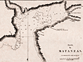 | Details | Direccion Hidrografia | 1809 |
| Puerto de Matanzas, Cuba |
|
Direccion Hidrografia |
|
| 1809 |
| LOC:77 |
| $400.00 | Direccion-Hidrografia | Puerto-de-Matanzas--Cuba | Scarce antique copperplate-engraved harbor chart of the Bay of Matanzas, Cuba on the northern coast of the island. Shows the then tiny Pueblo de San Carlos de Matanzas. Key features include Rio de Matanzas, Rio de Yumuris, Rio Canima, and the Castillo de San Severino, built in 1735. Bombed by the British in 1762, it was rebuilt in the 1770s. The Castillo became an offloading point for slaves and today is the site of the slavery-themed Museo de la Ruta de los Esclavos.
<BR> </BR>
Published in 1809, this rare chart was one of 34 charts of Cuban ports published by the Spanish Admiralty, the Direccion Hidrografia, in the sea atlas "Portolano de la America Setentrional Construido en la Direccion Detrabajos Hidrograficos". A fine example with careful, delicate engraving and a wide platemark on high-quality paper. Distance scale is in cables. Engraved by J.C. Part 3, Cuba. Plate #29.
<BR> </BR>
Reference: Materiales para una Cartografia Mexicana. Manuel Orozco y Berra. 1871. p. 216. |
| 239 |  | Details | Direccion Hidrografia | 1809 |
| Puerto de Nuevas Grandes |
|
Direccion Hidrografia |
|
| 1809 |
| LOC:5 |
| $400.00 | Direccion-Hidrografia | Puerto-de-Nuevas-Grandes | Beautiful, black and white engraved copperplate chart of Puerto de Nuevas Grandes, in the province of Camaguey, on the northern coast of Cuba. Published in 1809, this chart was one of 34 charts of Cuban ports published by the Spanish Admiralty, the Direccion Hidrografia, in the sea atlas "Portolano de la America Setentrional Construido en la Direccion Detrabajos Hidrograficos". <BR> </BR>
A fine example with careful, delicate engraving and a wide platemark on high-quality paper. Distance scale is in cables. Engraved by J.C. Part 3. Plate #27.<BR> </BR>
Reference: Materiales para una Cartografia Mexicana. Manuel Orozco y Berra. 1871. p. 216.
<br></br>
<a href="/DireccionHidrografiaBackground.aspx" > See all items by Spain's Direccion de Hidrografia.</a> |
| 240 | 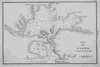 | Details | Direccion Hidrografia | 1809 |
| Puerto del Padre |
|
Direccion Hidrografia |
|
| 1809 |
| LOC:5 |
| $450.00 | Direccion-Hidrografia | Puerto-del-Padre | Beautiful, black and white engraved copperplate chart of Puerto del Padre, in the province of Las Tunas, on the northern coast of Cuba. Published in 1809, this chart was one of 34 charts of Cuban ports published by the Spanish Admiralty, the Direccion Hidrografia, in the sea atlas "Portolano de la America Setentrional Construido en la Direccion Detrabajos Hidrograficos". Puerto del Padre is one of several ports in Cuba that lay claim as the first spot in Cuba where Christopher Columbus landed on his well known 1492 exploration of the new world.<BR> </BR>
A fine example with careful, delicate engraving and a wide platemark on high-quality paper. Distance scale is in cables. Engraved by J.C. Part 3. Plate #25.<BR> </BR>
Reference: Materiales para una Cartografia Mexicana. Manuel Orozco y Berra. 1871. p. 216. |
| 241 | 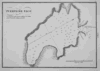 | Details | Direccion Hidrografia | 1809 |
| Puerto de Taco |
|
Direccion Hidrografia |
|
| 1809 |
| LOC:5 |
| $400.00 | Direccion-Hidrografia | Puerto-de-Taco | Beautiful, black and white engraved copperplate harbor chart of the Bahia de Taco, in the province of Guantanamo, on the far northeastern coast of Cuba. The Bahia de Taco lies very near a UNESCO world heritage site, the Parque National Alejandro de Humboldt. The 275 square mile park is one of the most biologically diverse sites in the Caribbean basin and is home to a 3832 foot mountain peak named El Todo.<BR> </BR>
Published in 1809, this chart of Puerto de Taco was one of 34 charts of Cuban ports published by the Spanish Admiralty, the Direccion Hidrografia, in the sea atlas "Portolano de la America Setentrional Construido en la Direccion Detrabajos Hidrograficos". A fine example with careful, delicate engraving and a wide platemark on high-quality paper. Distance scale is in cables. Part 3. Plate #9.<BR> </BR>
Reference: Materiales para una Cartografia Mexicana. Manuel Orozco y Berra. 1871. p. 216. |
| 242 | 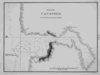 | Details | Direccion Hidrografia | 1809 |
| Puerto de Cananova |
|
Direccion Hidrografia |
|
| 1809 |
| LOC:5 |
| $400.00 | Direccion-Hidrografia | Puerto-de-Cananova | Beautiful, black and white engraved copperplate harbor chart of the shallow Bahia de Cananova, in the province of Holguin, on the northeastern coast of Cuba. It is generally accepted that Columbus landed in Holguin province on October 27, 1492 during his initial exploratory voyage, just two weeks after first landing in the New World at the Bahamas. <BR> </BR>
Published in 1809, this rare chart was one of 34 charts of Cuban ports published by the Spanish Admiralty, the Direccion Hidrografia, in the sea atlas "Portolano de la America Setentrional Construido en la Direccion Detrabajos Hidrograficos". A fine example with careful, delicate engraving and a wide platemark on high-quality paper. Distance scale is in cables. Engraved by J.C. Part 3. Plate #13.<BR> </BR>
Reference: Materiales para una Cartografia Mexicana. Manuel Orozco y Berra. 1871. p. 216. |
| 243 | 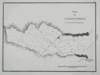 | Details | Direccion Hidrografia | 1809 |
| Puerto de Cayaguaneque (Cayoguaneque) |
|
Direccion Hidrografia |
|
| 1809 |
| LOC:5 |
| $400.00 | Direccion-Hidrografia | Puerto-de-Cayaguaneque-(Cayoguaneque) | Beautiful, black and white engraved copperplate harbor chart of Puerto de Cayaguaneque (or Cayoguaneque), Cuba a cove on the northeast coast of Cuba in Guantanamo province . <BR> </BR>
Published in 1809, this rare chart was one of 34 charts of Cuban ports published by the Spanish Admiralty, the Direccion Hidrografia, in the sea atlas "Portolano de la America Setentrional Construido en la Direccion Detrabajos Hidrograficos". A fine example with careful, delicate engraving and a wide platemark on high-quality paper. Distance scale is in cables. Engraved by J.C. Part 3. Plate #8.<BR> </BR>
Reference: Materiales para una Cartografia Mexicana. Manuel Orozco y Berra. 1871. p. 216. |
| 118 | 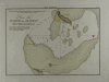 | Details | Direccion Hidrografia | 1809 |
| Plano del Puerto del Alacran |
|
Direccion Hidrografia |
|
| 1809 |
| LOC:5 |
| $400.00 | Direccion-Hidrografia | Plano-del-Puerto-del-Alacran | Small, extremely rare, antique copperplate island chart from the Direccion Hidrografia, Spain's equivalent of the Depot de la Marine in France. This chart is one of 66 charts from the second volume of the work published in 1809: "Portulano de la America Setentrional Construido en la Direccion Detrabajos Hidrograficos. Antique Spanish sea charts of their New World possessions from this time period are not often found.<BR> </BR>
About 65 miles from the Yucatan coast of Mexico the Alacranes (Scorpion) reef was declared a Marine Protection Area in 1994. The chart includes numerous soundings along with the composition of the sands near the reef. Shows 4 small islands: Isla de Perez, La Lavendera, Isla Chica, and Isla de Pajaras. North oriented at the right of the chart. |
| 371 |  | Details | Direccion Hidrografia | 1809 |
| Plano del Fondeadero Bleufields |
|
Direccion Hidrografia |
|
| 1809 |
| LOC:5 |
| $500.00 | Direccion-Hidrografia | Plano-del-Fondeadero-Bleufields | Chart of southwest coast of Jamaica near Bluefields Bay (Bleufields), near the current town of Belmond. Noted feature include El Fuerte on a point jutting into the Caribbean and a small rocky island "Arrecife del Moro". North is oriented to the left.
<BR> </BR>
Published in 1809, this large-scale port/harbor chart is one of 22 charts of ports in Haiti, Dominican Republic and Jamaica (on 16 plates) published by the Spanish Admiralty, the Direccion Hidrografia, in Part IV of the atlas "Portolano de la America Setentrional Construido en la Direccion Detrabajos Hidrograficos". Because of Spain's secrecy about its New World territories these charts represent some of the earliest detailed charts of these areas. These small charts do not often appear on the market. Plate Number 6. Scale in cables.<BR> </BR>
Reference: Materiales para una Cartografia Mexicana. Manuel Orozco y Berra. 1871. p. 216. |
| 372 |  | Details | Direccion Hidrografia | 1809 |
| Puerto de Mosquito (Jamayca) |
|
Direccion Hidrografia |
|
| 1809 |
| LOC:5 |
| $500.00 | Direccion-Hidrografia | Puerto-de-Mosquito-(Jamayca) | Chart of Mosquito Cove on the north coast of Jamaica (Jamayca) near Barbican and between Lucea Harbor and Sandy Bay . North is oriented to the bottom. Numerous soundings and hazards are marked. Plate Number 4. Scale in cables.<BR> </BR>
Published in 1809, this large-scale port/harbor chart is one of 22 charts of ports in Haiti, Dominican Republic and Jamaica (on 16 plates) published by the Spanish Admiralty, the Direccion Hidrografia, in Part IV of the atlas "Portolano de la America Septentrional Construido en la Direccion Detrabajos Hidrograficos". Because of Spain's secrecy about its New World territories these charts represent some of the earliest detailed charts of these areas. <BR> </BR>
Reference: Materiales para una Cartografia Mexicana. Manuel Orozco y Berra. 1871. p. 216. |
| 373 |  | Details | Direccion Hidrografia | 1809 |
| Puerto Antonio (Jamayca) |
|
Direccion Hidrografia |
|
| 1809 |
| LOC:5 |
| $500.00 | Direccion-Hidrografia | Puerto-Antonio-(Jamayca) | Chart of Puerto Antonio, the capital of the parish of Portland, on the northeast coast of Jamaica (Jamayca) Legend at right identifies 8 features including a church, fortress, and watering spot. North is oriented to the bottom. Numerous soundings, rocks, and hazards are marked. Plate Number 1. Scale in cables.<BR> </BR>
Published in 1809, this large-scale port/harbor chart is one of 22 charts of ports in Haiti, Dominican Republic and Jamaica (on 16 plates) published by the Spanish Admiralty, the Direccion Hidrografia, in Part IV of the atlas "Portolano de la America Septentrional Construido en la Direccion Detrabajos Hidrograficos". Because of Spain's secrecy about its New World territories these charts represent some of the earliest detailed charts of these areas. <BR> </BR> |
| 374 |  | Details | Direccion Hidrografia | 1809 |
| Plano de Puerto de Delfin (Santo Domingo) |
|
Direccion Hidrografia |
|
| 1809 |
| LOC:5 |
| $500.00 | Direccion-Hidrografia | Plano-de-Puerto-de-Delfin-(Santo-Domingo) | Interesting chart of what is today the Bay of Fort Liberte, Haiti. The city of Fort Liberte has changed hands several times and with each occupation the French, Spanish, and British renamed the city: from Bayaha, to Fort-Dauphin (Delfin in Spanish for dolphin), to Fort St. Joseph and finally in 1820 to Fort Liberte. The chart shows a sizeable settlement and a legend to the right explains several of the key features including two cannon batteries and four forts: Fuerte Ardubin, Fuerte Federico, Fuerte de la Boca, and Fuerte Delfin. Plate Number 3. Scale in cables.<BR> </BR>
Published in 1809, this large-scale port/harbor chart is one of 22 charts of ports in Haiti, Dominican Republic and Jamaica (on 16 plates) published by the Spanish Admiralty, the Direccion Hidrografia, in Part IV of the atlas "Portolano de la America Septentrional Construido en la Direccion Detrabajos Hidrograficos". Because of Spain's secrecy about its New World territories these charts represent some of the earliest detailed charts of these areas. <BR> </BR> |
| 375 | 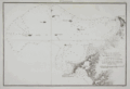 | Details | Direccion Hidrografia | 1809 |
| Plano de las Ensenadas de Monte-Cristi y Manzanillo |
|
Direccion Hidrografia |
|
| 1809 |
| LOC:200 |
| $450.00 | Direccion-Hidrografia | Plano-de-las-Ensenadas-de-Monte-Cristi-y-Manzanillo | Early chart by the Direccion Hidrografia of the northwest coast of the Dominican Republic including the Bay of Montecristi and the Bay of Manzanillo and the town of Montecristi. Much of this area now comprises the Parque Nacional Montecristi. The chart's coverage includes the offshore islands in that area, doubtless the source of the name "los siete hermanos" (the seven brothers) including Cayo de Arenas, Cayo Rataas, Cayo Tercero, Cayo de Muertos, and Cayo Totoru . Somewhat larger that the other charts from the Portolano. Plate Number 2. Scale in cables.<BR> </BR>
Published in 1809, this large-scale port/harbor chart is one of 22 charts of ports in Haiti, Dominican Republic and Jamaica (on 16 plates) published by the Spanish Admiralty, the Direccion Hidrografia, in Part IV of the atlas "Portolano de la America Septentrional Construido en la Direccion Detrabajos Hidrograficos". Because of Spain's secrecy about its New World territories these charts represent some of the earliest detailed charts of these areas. <BR> </BR> |
| 376 | 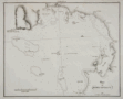 | Details | Direccion Hidrografia | 1809 |
| Plano de Bahia Antigua |
|
Direccion Hidrografia |
|
| 1809 |
| LOC:200 |
| $400.00 | Direccion-Hidrografia | Plano-de-Bahia-Antigua | Chart by the Direccion Hidrografia of the southern coast of Jamaica centered on what is today called Moore's Pen. When the chart was published a small settlement in that area is noted as "Bahia Antigua". Coverage includes Great Goat Island, Ridley's Bay, Coleman's Bay, Salt River Bay, Peake Bay, Mahoe Gardens, and Portland Point although places names on the chart from 1809 do not always correspond to today's. Somewhat larger that the other charts from the Portolano. Plate Number 7. Scale in cables.<BR> </BR>
Published in 1809, this large-scale port/harbor chart is one of 22 charts of ports in Haiti, Dominican Republic and Jamaica (on 16 plates) published by the Spanish Admiralty, the Direccion Hidrografia, in Part IV of the atlas "Portolano de la America Septentrional Construido en la Direccion Detrabajos Hidrograficos". Because of Spain's secrecy about its New World territories these charts represent some of the earliest detailed charts of these areas. <BR> </BR> |
| 359 | 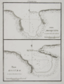 | Details | Direccion Hidrografia | 1809 |
| Bahia Mosquito, Puerto Escudo |
|
Direccion Hidrografia |
|
| 1809 |
| LOC:5 |
| $400.00 | Direccion-Hidrografia | Bahia-Mosquito--Puerto-Escudo | Rare nautical / harbor charts of Bahia Mosquito and Puerto Escudo, Santo Domingo (Dominican Republic).
<BR> </BR>
Published in 1809, these antique large-scale port/harbor charts are two of 22 charts of ports in Haiti, Dominican Republic and Jamaica (on 16 plates) published by the Spanish Admiralty, the Direccion Hidrografia, in Part IV of the atlas "Portolano de la America Setentrional Construido en la Direccion Detrabajos Hidrograficos". Because of Spain's secrecy about its New World territories these charts represent some of the earliest detailed charts of these areas. These antique nautical charts do not often appear on the market. Plate Number 7. Scale in cables.<BR> </BR>
Reference: Materiales para una Cartografia Mexicana. Manuel Orozco y Berra. 1871. p. 216. |
| 360 | 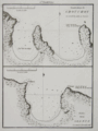 | Details | Direccion Hidrografia | 1809 |
| Fondeadero de Chouchou, Bahia de la Granja |
|
Direccion Hidrografia |
|
| 1809 |
| LOC:5 |
| $400.00 | Direccion-Hidrografia | Fondeadero-de-Chouchou--Bahia-de-la-Granja | Antique nautical / harbor charts of Fondeadero de Chouchou (N. coast of Haiti) and Bahia de la Granja, Haiti.<BR> </BR>
Published in 1809, these two large-scale port/harbor charts are two of 22 charts (on 16 plates) of ports in Haiti, Dominican Republic and Jamaica published by the Spanish Admiralty, the Direccion Hidrografia, in Part IV of the atlas "Portolano de la America Setentrional Construido en la Direccion Detrabajos Hidrograficos". Because of Spain's secrecy about its New World territories these antique harbor charts represent some of the earliest detailed charts of these areas. These small charts do not often appear on the market. Plate Number 5. Scale in cables.<BR> </BR>
Reference: Materiales para una Cartografia Mexicana. Manuel Orozco y Berra. 1871. p. 216. |
| 361 | 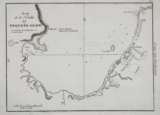 | Details | Direccion Hidrografia | 1809 |
| Plano de la Bahia del Pequeno Guave |
|
Direccion Hidrografia |
|
| 1809 |
| LOC:5 |
| $500.00 | Direccion-Hidrografia | Plano-de-la-Bahia-del-Pequeno-Guave | Rare antique nautical / harbor chart of Pequeno Guave (Petit-Goâve) Haiti, one of the oldest cities in the country. Coverage includes from punta Agujereada to punta de Piedras.<BR> </BR>
Published in 1809, this large-scale port/harbor chart is one of 22 charts (on 16 plates) of ports in Haiti, Dominican Republic and Jamaica published by the Spanish Admiralty, the Direccion Hidrografia, in Part IV of the atlas "Portolano de la America Setentrional Construido en la Direccion Detrabajos Hidrograficos". Because of Spain's secrecy about its New World territories these charts represent some of the earliest detailed charts of these areas. These antique charts do not often appear on the market. Plate Number 11. Scale in cables.<BR> </BR>
Reference: Materiales para una Cartografia Mexicana. Manuel Orozco y Berra. 1871. p. 216. |
| 362 | 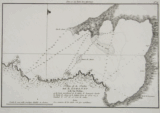 | Details | Direccion Hidrografia | 1809 |
| Plano de la Bahia de S. Lorenzo |
|
Direccion Hidrografia |
|
| 1809 |
| LOC:5 |
| $400.00 | Direccion-Hidrografia | Plano-de-la-Bahia-de-S--Lorenzo | l scarce harbor chart of San Lorenzo Bay, near Sabana de La Mar, in Hato Mayor, Santo Domingo (now the Dominican Republic). Coverage includes several sandbanks and Rio San Lorenzo.<BR> </BR>
Published in 1809, this large-scale antique port/harbor chart is one of 22 charts (on 16 plates) of ports in Haiti, Dominican Republic and Jamaica published by the Spanish Admiralty, the Direccion Hidrografia, in Part IV of the atlas "Portolano de la America Setentrional Construido en la Direccion Detrabajos Hidrograficos". Because of Spain's secrecy about its New World territories these charts represent some of the earliest detailed charts of these areas. These antique nautical charts do not often appear on the market. Plate Number 16. Scale in nautical miles ("milla maritima").<BR> </BR>
Reference: Materiales para una Cartografia Mexicana. Manuel Orozco y Berra. 1871. p. 216. |
| 363 |  | Details | Direccion Hidrografia | 1809 |
| Punta de la Caldera |
|
Direccion Hidrografia |
|
| 1809 |
| LOC:5 |
| $400.00 | Direccion-Hidrografia | Punta-de-la-Caldera | Scare antique nautical harbor chart of Punta de la Caldera (Calderas), Santo Domingo (now the Dominican Republic), on the south coast of that island. Coverage includes from punta de Burros to punta de Salinas. At the location where the Base Naval de las Calderas is now located there is depicted a single small shack. Other features include: punta Intermedia, Punta de Mata-Sola, Caleton, punta Morrillos, casimba de agua dulce (Translated: 'bucket of sweet water'), punta de las Garzas, and punta Rancheros. Numerous soundings, anchorages, and rocks are noted.<BR> </BR>
Published in 1809, this large-scale port/harbor chart is one of 22 charts (on 16 plates) of ports in Haiti, Dominican Republic and Jamaica published by the Spanish Admiralty, the Direccion Hidrografia, in Part IV of the atlas "Portolano de la America Setentrional Construido en la Direccion Detrabajos Hidrograficos". Because of Spain's secrecy about its New World territories these charts represent some of the earliest detailed charts of these areas. These small antique charts do not often appear on the market. Plate Number 13. Scale in cables.<BR> </BR>
Reference: Materiales para una Cartografia Mexicana. Manuel Orozco y Berra. 1871. p. 216. |
| 364 |  | Details | Direccion Hidrografia | 1809 |
| Puerto del Mole de San Nicolas |
|
Direccion Hidrografia |
|
| 1809 |
| LOC:5 |
| $400.00 | Direccion-Hidrografia | Puerto-del-Mole-de-San-Nicolas | On the northwest section of Haiti, Mole San Nicolas is located just 50 miles from Baracoa, Cuba. This rare chart of the bay and harbor chart of Mole San Nicolas shows the city firmly established at the time of the survey with these features: Almacen de Polvora (gunpowder magazine), quarteles, and la Ciudad protected by a defensive wall.<BR> </BR>
Published in 1809, this large-scale port/harbor chart is one of 22 charts (on 16 plates) of ports in Haiti, Dominican Republic and Jamaica published by the Spanish Admiralty, the Direccion Hidrografia, in Part IV of the atlas "Portolano de la America Setentrional Construido en la Direccion Detrabajos Hidrograficos". Because of Spain's secrecy about its New World territories these charts represent some of the earliest detailed charts of these areas. These small charts do not often appear on the market. Plate Number 9. Scale in cables.<BR> </BR>
Reference: Materiales para una Cartografia Mexicana. Manuel Orozco y Berra. 1871. p. 216. |
| 244 | 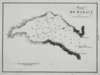 | Details | Direccion Hidrografia | 1809 |
| Puerto de Maravi (Bahia de Maravi) |
|
Direccion Hidrografia |
|
| 1809 |
| LOC:5 |
| $400.00 | Direccion-Hidrografia | Puerto-de-Maravi-(Bahia-de-Maravi) | Beautiful, black and white engraved copperplate chart of the Bay of Maravi, Cuba a cove on the northeast coast of Cuba in Guantanamo province. <BR> </BR>
Published in 1809, this rare chart of Maravi Bay was one of 34 charts of Cuban ports published by the Spanish Admiralty, the Direccion Hidrografia, in the sea atlas "Portolano de la America Setentrional Construido en la Direccion Detrabajos Hidrograficos". A fine example with careful, delicate engraving and a wide platemark on high-quality paper. Distance scale is in cables. Engraved by J.C. Part 3. Plate #6.<BR> </BR>
Reference: Materiales para una Cartografia Mexicana. Manuel Orozco y Berra. 1871. p. 216. |
| 245 |  | Details | Direccion Hidrografia | 1809 |
| Puerto de Baitiqueri |
|
Direccion Hidrografia |
|
| 1809 |
| LOC:5 |
| $400.00 | Direccion-Hidrografia | Puerto-de-Baitiqueri | Beautiful, black and white engraved copperplate chart of the Bay of Baitiqueri, Cuba on the northeast coast of Cuba in Guantanamo province. <BR> </BR>
Published in 1809, this rare chart was one of 34 charts of Cuban ports published by the Spanish Admiralty, the Direccion Hidrografia, in the sea atlas "Portolano de la America Setentrional Construido en la Direccion Detrabajos Hidrograficos". A fine example with careful, delicate engraving and a wide platemark on high-quality paper. Distance scale is in cables. Part 3. Plate #3.<BR> </BR>
Reference: Materiales para una Cartografia Mexicana. Manuel Orozco y Berra. 1871. p. 216. |
| 246 |  | Details | Direccion Hidrografia | 1809 |
| Puerto de Jaragua (Bahia de Jaragua) |
|
Direccion Hidrografia |
|
| 1809 |
| LOC:5 |
| $400.00 | Direccion-Hidrografia | Puerto-de-Jaragua-(Bahia-de-Jaragua) | Beautiful, black and white engraved copperplate chart of the Bay of Jaragua, Cuba on the northeast coast of Cuba in Guantanamo province. <BR> </BR>
Published in 1809, this rare chart of Jaragua bay was one of 34 charts of Cuban ports published by the Spanish Admiralty, the Direccion Hidrografia, in the sea atlas "Portolano de la America Setentrional Construido en la Direccion Detrabajos Hidrograficos". A fine example with careful, delicate engraving and a wide platemark on high-quality paper. Distance scale is in cables. Engraved by J.C. Part 3. Plate #10.<BR> </BR>
Reference: Materiales para una Cartografia Mexicana. Manuel Orozco y Berra. 1871. p. 216. |
| 247 |  | Details | Direccion Hidrografia | 1809 |
| Puerto de Navas (Bahia Navas) |
|
Direccion Hidrografia |
|
| 1809 |
| LOC:5 |
| $400.00 | Direccion-Hidrografia | Puerto-de-Navas-(Bahia-Navas) | Beautiful, black and white engraved copperplate chart of the Bay of Navas, Cuba on the northeast coast of Cuba in Guantanamo province. Navas is about 2.3 km northwest of Cayoguaneque.<BR> </BR>
Published in 1809, this rare chart of Navas Bay was one of 34 charts of Cuban ports published by the Spanish Admiralty, the Direccion Hidrografia, in the sea atlas "Portolano de la America Setentrional Construido en la Direccion Detrabajos Hidrograficos". A fine example with careful, delicate engraving and a wide platemark on high-quality paper. Distance scale is in cables. Part 3. Plate #7.<BR> </BR>
Reference: Materiales para una Cartografia Mexicana. Manuel Orozco y Berra. 1871. p. 216. |
| 248 | 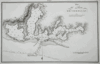 | Details | Direccion Hidrografia | 1809 |
| Plano del Puerto de Cebollas (Bahia de Cebollas) |
|
Direccion Hidrografia |
|
| 1809 |
| LOC:5 |
| $600.00 | Direccion-Hidrografia | Plano-del-Puerto-de-Cebollas-(Bahia-de-Cebollas) | Beautiful, black and white engraved copperplate chart of the Bay of Cebollas, Cuba on the northeast coast of Cuba in Holguin province. Strong graphic composition; this engraving and the plate of Puerto de Vita would make a fine grouping. This chart is about 20% larger than other port plans in this series.<BR> </BR>
Published in 1809, this rare chart of Cebollas Bay was one of 34 charts of Cuban ports published by the Spanish Admiralty, the Direccion Hidrografia, in the sea atlas "Portolano de la America Setentrional Construido en la Direccion Detrabajos Hidrograficos". A fine example with careful, delicate engraving and a wide platemark on high-quality paper. Distance scale is in cables. Part 3. Plate 14.<BR> </BR>
Reference: Materiales para una Cartografia Mexicana. Manuel Orozco y Berra. 1871. p. 216. |
| 249 | 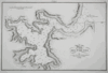 | Details | Direccion Hidrografia | 1809 |
| Plano del Puerto de Vita |
|
Direccion Hidrografia |
|
| 1809 |
| LOC:5 |
| $650.00 | Direccion-Hidrografia | Plano-del-Puerto-de-Vita | Beautiful, black and white copperplate engraved chart of the Port of Vita, Cuba on the northeast coast of Cuba in Holguin province. Commerce at the Puerto de Vita, Cuba includes the Marina Internacional Puerto de Vita with moorings for 38 boats. The port is reported to offer sufficient protection from hurricanes and also is one of the few Cuban ports where small cruising boats can clear customs. <BR> </BR>
Strong graphic composition; this engraving and the plate of Puerto de Cebollas would make a fine grouping. This chart is about 20% larger than other port plans in this series. Published in 1809, this rare chart of Puerto de Vita was one of 34 charts of Cuban ports published by the Spanish Admiralty, the Direccion Hidrografia, in the sea atlas "Portolano de la America Setentrional Construido en la Direccion Detrabajos Hidrograficos". A fine example with careful, delicate engraving and a wide platemark on high-quality paper. Distance scale is in cables. Part 3. Plate 21.<BR> </BR>
Reference: Materiales para una Cartografia Mexicana. Manuel Orozco y Berra. 1871. p. 216. |
| 238 | 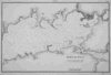 | Details | Direccion Hidrografia | 1809 |
| Bahia de Jagua (Cienfuegos) |
|
Direccion Hidrografia |
|
| 1809 |
| LOC:5 |
| $0.00 | Direccion-Hidrografia | Bahia-de-Jagua-(Cienfuegos) | Enquire for price.
<BR> </BR>
Beautiful antique, black and white engraved copperplate port plan of Jagua Bay, (now Cienfuegos) on the southern coast of Cuba. Published in 1809, this chart of Cienfuegos Bay was one of 34 charts of Cuban ports published by the Spanish Admiralty, the Direccion Hidrografia, in the sea atlas "Portolano de la America Setentrional Construido en la Direccion Detrabajos Hidrograficos". <BR> </BR>
Highlights include a fortress, 'Castillo de Nuestra Señora de los Angeles', built in 1745 at the mouth of the bay for protection from pirates. Unlike many other port plans, very few structures are noted and the position of the Castillo is hardly noticeable as it represented with only a very small double circle and even smaller lettering. A fine example with careful, delicate engraving and a wide platemark on high-quality paper. Distance scale is in cables. Engraved by T.G. Part 3. Plate #33.<BR> </BR>
Reference: Materiales para una Cartografia Mexicana. Manuel Orozco y Berra. 1871. p. 216.
<br></br>
<a href="/DireccionHidrografiaBackground.aspx" > See all items by Spain's Direccion de Hidrografia.</a> |
| 237 | 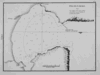 | Details | Direccion Hidrografia | 1809 |
| Puerto de Gibara |
|
Direccion Hidrografia |
|
| 1809 |
| LOC:5 |
| $400.00 | Direccion-Hidrografia | Puerto-de-Gibara | Beautiful, black and white engraved copperplate port plan of the port of Gibara on northeast coast of Cuba. Published in 1809, before the town of Gibara was founded, this antique plan / chart is one of 34 charts of Cuban ports published by the Spanish Admiralty, the Direccion Hidrografia, in the sea atlas "Portolano de la America Setentrional Construido en la Direccion Detrabajos Hidrograficos". <BR> </BR>
A fine example with careful, delicate engraving and a wide platemark on high-quality paper. Distance scale is in cables. Part 3. Plate #24.<BR> </BR>
Reference: Materiales para una Cartografia Mexicana. Manuel Orozco y Berra. 1871. p. 216.
<br></br>
<a href="/DireccionHidrografiaBackground.aspx" > See all items by Spain's Direccion de Hidrografia.</a> |
| 236 | 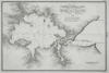 | Details | Direccion Hidrografia | 1809 |
| Plano del Puerto de Banes |
|
Direccion Hidrografia |
|
| 1809 |
| LOC:5 |
| $400.00 | Direccion-Hidrografia | Plano-del-Puerto-de-Banes | Beautiful, black and white engraved copperplate port plan of Banes, Cuba, birthplace of former dictator Fulgencio Batista, located on the northeast coast of that island nation. Published in 1809, this antique chart of Banes harbor is one of 34 charts of ports in Cuba published by the Spanish Admiralty, the Direccion Hidrografia, in the sea atlas "Portolano de la America Setentrional Construido en la Direccion Detrabajos Hidrograficos". <BR> </BR>
Highlights include elaborate calligraphic title and spare, careful engraving with a wide platemark on high-quality paper. Distance scale is in cables. Engraved by J.C. Part 3. Plate #18.<BR> </BR>
Reference: Materiales para una Cartografia Mexicana. Manuel Orozco y Berra. 1871. p. 216.
<br></br>
<a href="/DireccionHidrografiaBackground.aspx" > See all items by Spain's Direccion de Hidrografia.</a> |
| 4788 |  | Details | Direccion Hidrografia | 1813 |
| Rare Antique Plan of the Port and Anchorage at Barcelona, Spain |
|
Direccion Hidrografia |
|
| 1813 |
| LOC:88 |
| $600.00 | Direccion-Hidrografia | Rare-Antique-Plan-of-the-Port-and-Anchorage-at-Barcelona--Spain | Very interesting antique Spanish chart / port plan of Barcelona, Spain on the Mediterranean Sea. One of 16 charts and plans published by Spain's Direccion Hidrografia in the rare Spanish hydrographic atlas: "Portulano de las Costas de la Península de España, Islas adyacentes, y parte de la Costa de Africa. Construido y publicado en la Direccion Hidrografica, Cadiz ano 1813."
<br></br>
With (now faded) MS dedication and attached anchoring instructions, both in English. The dedication read "Presented by W??????? To his fd (friend?) Mr. Fleming Cadiz July 12, 1816." That date is 3 years after the atlas was first issued from Cadiz.
<br></br>
Scarce, no copy in AMPR
<br></br>
Included manuscript sailing directions reads
<div class="indenttextblock">
"In the outside Harbour of Barcelona to protect yourself of the E. and S.E. winds, anchor as follows= The light with the Tower of Merced and the coast of Garaf open on the south of Montjuif, anchoring in 18 - 25 f[athoms]mostly sand, from which … an east wind you can pass the Llobregat."
</div>
<BR/>
A circled spot on the map with light penciled isobaths (contour lines) at 10 and 20 fathoms seem to support the anchoring recommendation in the sailing directions.
<br></br>
Depth soundings are in "pies castellanos" ( 1 Castillian foot = .2786 m or .914 feet). |
| 641 |  | Details | Direccion Hidrografia | 1815 |
| Mouth of the Plate River to Buenos Aires |
|
Direccion Hidrografia |
|
| 1815 |
| LOC:0 |
| $0.00 | Direccion-Hidrografia | Mouth-of-the-Plate-River-to-Buenos-Aires | SOLD<br></br>
Antique Spanish nautical chart of the Plate River, Montevideo and Buenos Aires, Argentina. This scarce sea chart is the 1815 corrected version of a chart first published in 1812 by Spain's Direccion Hidrographia. Laid to brown linen, probably when issued, in order to help the chart stand the rigors of a life at sea.
<br><br/>
With two detailed inset port plans: Plano del Puerto de Maldonado and Plano del Puerto de Monte-video. Also, at top are three profile coastal views.
<br><br/>
With the emblem of the Direccion Hidrographia. |
| 5262 |  | Details | Direccion Hidrografia | 1816 |
| Rare harbor chart of Cartagena, Colombia |
|
Direccion Hidrografia |
|
| 1816 |
| LOC:88 |
| $0.00 | Direccion-Hidrografia | Rare-harbor-chart-of-Cartagena--Colombia | Sold<br><br>Rare harbor chart of Cartagena, Colombia. North is oriented to the right. Numerous soundings and hazards are marked. Plate Number 19.
<br></br>
Published in 1809, this large-scale port/harbor chart is one of 41 charts of ports in Part II of the atlas "Portolano de la America Septentrional Construido en la Direccion Detrabajos Hidrograficos" containing charts from the USA (Florida and Texas), Mexico, Nicaragua, Panama, and Colombia. Because of Spain's secrecy about its New World territories this chart represents the earliest easily available cartographic record of this area from Spanish sources. |
| 1145 | 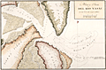 | Details | Direccion Hidrografia | 1818 |
| Boca y Barra Del Rio Nasau |
|
Direccion Hidrografia |
|
| 1818 |
| LOC:200 |
| $1,475.00 | Direccion-Hidrografia | Boca-y-Barra-Del-Rio-Nasau | Rare Spanish nautical chart of the mouth (boca) and bar (barra) in Nassau Sound, Florida in 1818. One of the earliest available large-scale charts of the entrance to the Nassau River and the coastal margins near that waterway which divides Amelia Island from Talbot Island.
<br></br>
From the second part of "Portolano de la America Septentrional Construido en la Direccion Detrabajos Hidrograficos" published in 1818 by Spain's Admiralty department, the
<a href="https://www.rarecharts.com/DireccionHidrografiaBackground.aspx " target="_blank">Dirección de Hidrografía. </a> Plate 326. |
| 4774 | 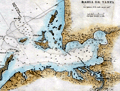 | Details | Direccion Hidrografia | 1818 |
| Scarce antique Spanish chart of Tampa Bay, Florida |
|
Direccion Hidrografia |
|
| 1818 |
| LOC:200 |
| $1,650.00 | Direccion-Hidrografia | Scarce-antique-Spanish-chart-of-Tampa-Bay--Florida | A scarce Spanish antique nautical chart of a large area now encompassing St. Petersburg and Tampa, Florida, and all of Tampa Bay. With anchorages identified, depth soundings, and several Spanish place-names. One unidentified location, "Cayo de Aguada" or Watering Key, remains unknown to me. That location likely would have been very attractive to pirates and privateers as it offered both close proximity to fresh water and to the nearby deeper entrance channels to Tampa Bay.
<br></br>
Contains numerous coastal locations with their second-Spanish period names: Longboat Key ("Id. Larga"), Passage Key ("Cayo del Passage"), Sweetwater Creek ("Rio de Aguadulce"), Little Manatee River ("Rio de Manaties"), Point Pinellas (Punta de Pinar [Sp. pine]). During the research for Spanish place-names our search turned up an exact match for "Punta de Piedras" or Rocky Point on the northeast shore of Old Tampa Bay. Unfortunately, that location for "Punta de Piedras" is on the wrong side of the bay. The search continues.
<br></br>
From the second part of "Portolano de la America...", published in 1818 by Spain's Admiralty department, the Dirección de Hidrografía. In 1809 the Direccion first published this atlas of plans of bays, harbors, and ports from Spain’s New World possessions: "Portolano de la America Septentrional Construido en la Direccion de Trabajos Hidrograficos". Plate 36. |
| 1290 | 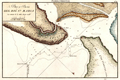 | Details | Direccion Hidrografia | 1818 |
| Scarce Spanish chart of north Amelia Island and St. Marys River bar. |
|
Direccion Hidrografia |
|
| 1818 |
| LOC:200 |
| $1,350.00 | Direccion-Hidrografia | Scarce-Spanish-chart-of-north-Amelia-Island-and-St--Marys-River-bar- | A scarce Spanish nautical chart of the mouth (boca) and bar (barra) of the Saint Mary's River, Florida. A scholarly summary of the map from the University of Miami notes the rarity of this small antique chart:
<div class="indenttextblock">
"This <b>rare map</b> shows the St. Marys River, which is the northern border of eastern Florida. It is from a Spanish portfolio showing harbor areas in its last colony in North America's eastern portion. <b>Very few maps are available that were made by them in the second Spanish Period</b>." <a href="http://scholar.library.miami.edu/floridamaps/view_image.php?image_name=dlp00020000860001001&group=cartographer" target="_blank">Internet. </a>
</div>
No record of the sale of the "Rio Santa Maria" map is reported in the Antique Map Price Record.
<br></br>
Includes portions of Fernandina Beach and north Amelia Island, Florida; Little Tiger Island, Florida; and south Cumberland Island Georgia.
<br></br>
Over 200 years ago, this chart of the bar with depth soundings, would have been very useful to mariner's entering or departing the St. Marys river. Shows "Fort Arruinado" ( Fort William ) on the southern tip of Cumberland Island.
<br></br>
The St. Marys River is a remote blackwater stream, located in southeastern Georgia and northeastern Florida, forming the easternmost border between the two states. The St. Marys serves as critical habitat for numerous rare, threatened or endangered species.
<br></br>
From the second part of "Portolano de la America...", published in 1818 by Spain's Admiralty department, the Dirección de Hidrografía. In 1809 the Direccion first published this atlas of plans of bays, harbors, and ports from Spain’s New World possessions: "Portolano de la America Septentrional Construido en la Direccion de Trabajos Hidrograficos". (Updated in 1818). Plate 40. |
| 1291 | 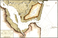 | Details | Direccion Hidrografia | 1818 |
| Antique Spanish chart of the mouth of St. Johns River, Florida |
|
Direccion Hidrografia |
|
| 1818 |
| LOC:200 |
| $1,325.00 | Direccion-Hidrografia | Antique-Spanish-chart-of-the-mouth-of-St--Johns-River--Florida | A scarce Spanish nautical chart by the Direccion Hidrografia of the mouth (boca) and bar (barra) of the Saint Johns River, Florida near Jacksonville. A scholarly summary by the the University of Miami of a similar map notes the rarity of these early antique Spanish charts:
<div class="indenttextblock">
"It is from a Spanish portfolio showing harbor areas in its last colony in North America's eastern portion. <b>Very few maps are available that were made by them in the second Spanish Period</b>." <a href="http://scholar.library.miami.edu/floridamaps/view_image.php?image_name=dlp00020000860001001&group=cartographer" target="_blank">Internet. </a>
</div>
<br></br>
North is oriented at the upper right.
<br></br>
The St. Johns is the longest river in Florida - 310 miles long. It is one of the few rivers in the United States that flows north. The source of the river is a large marshy area in Indian River County that flows north and turns eastward at Jacksonville, FL to its mouth in the Atlantic Ocean.
<br></br>
From the second part of "Portolano de la America...", published in 1818 by Spain's Admiralty department, the Dirección de Hidrografía. In 1809 the Direccion first published this atlas of plans of bays, harbors, and ports from Spain’s New World possessions: "Portolano de la America Septentrional Construido en la Direccion de Trabajos Hidrograficos". (Updated in 1818). Plate 40. |
| 1300 | 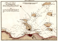 | Details | Direccion Hidrografia | 1818 |
| Antique Spanish chart the port of Veracruz, Mexico. |
|
Direccion Hidrografia |
|
| 1818 |
| LOC:10 |
| $850.00 | Direccion-Hidrografia | Antique-Spanish-chart-the-port-of-Veracruz--Mexico- | A scarce Spanish nautical chart of the harbor, islands, and waters surrounding Veracruz, Mexico. An original antique navigation chart by the Direccion Hidrografia; the detailed chart is dotted with numerous depth soundings and notation of composition of the sea floor, e.g. arena (sand), piedra (rock), and lama (mud).
<br></br>
Place names and features on this old Spanish harbor chart include Castillo de San Juan de Ulua, Arrecife e Isla de Pajaros, Arrecife de la Blanquilla, Punta de la Gallega, Punta de Hornos, and Arrecife de Punta Gorda and Arrecife e Isla de Sacrificios. Isla de Sacrificios has a bloody past. Bernal Diaz del Castillo reports that when the Spanish first landed on the Isla de Sacrificios:
<div class="indenttextblock">
"We found two stone buildings of good workmanship, each with a flight of steps leading up to a kind of altar, and on those altars were evil-looking idols, which were their gods. Here we found five Indians who had been sacrificed to them on that very night. Their chests had been struck open and their arms and thighs cut off, and the walls of these buildings were covered in blood. All this amazed us greatly, and we called this island the Isla de Sacrificios, as it is now named on the charts."
</div>
<BR/>
From the second part of "Portolano de la America...", published in 1818 by Spain's Admiralty department, the Dirección de Hidrografía. In 1809 the Direccion first published this atlas of plans of bays, harbors, and ports from Spain’s New World possessions: "Portolano de la America Septentrional Construido en la Direccion de Trabajos Hidrograficos". (Updated in 1818). Plate 52. |
| 5406 | 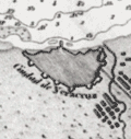 | Details | Direccion Hidrografia | 1818 |
| Plano del Puerto de Veracruz situado el Castillo de San Juan de Ulua Mexico |
|
Direccion Hidrografia |
|
| 1818 |
| LOC: |
| $375.00 | Direccion-Hidrografia | Plano-del-Puerto-de-Veracruz-situado-el-Castillo-de-San-Juan-de-Ulua-Mexico | Fine, original, engraved Spanish nautical chart of the harbor, islands, and waters surrounding Veracruz, Mexico by the Direccion Hidrografia [1]. The detailed chart is dotted with numerous depth soundings and notation of composition of the sea floor, e.g. arena (sand), piedra (rock), and lama (mud).
<br></br>
Place names and features on this old Spanish harbor chart include [2]:
<div class="indenttextblocksingle">
<ul style="list-style-type: circle;">
<li>Castillo de San Juan de Ulua</li>
<li>Arrecife e Isla de Pajaros</li>
<li>Arrecife de la Blanquilla</li>
<li>Punta de la Gallega</li>
<li>Punta de Hornos</li>
<li>Arrecife de Punta Gorda</li>
<li>Arrecife e Isla de Sacrificios</li>
<li>Anegada de adentro</li>
<li>Arrecife de Isla Verde</li>
</ul>
</div>
[1] From the second part of "Portolano de la America...", published in 1818 by Spain's Admiralty department, the Dirección de Hidrografía. In 1809 the Direccion first published this atlas of plans of bays, harbors, and ports from Spain’s New World possessions: "Portolano de la America Septentrional Construido en la Direccion de Trabajos Hidrograficos". Plate 52.<br/>
[2] Arrecife = reef; Isla = island; Anegada = flooded or underwater. |
| 942 | 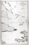 | Details | Direccion Hidrografia | 1867 |
| Antique Spanish Chart of Eastern Cuba and the Bahama Bank |
|
Direccion Hidrografia |
|
| 1867 |
| LOC:0 |
| $900.00 | Direccion-Hidrografia | Antique-Spanish-Chart-of-Eastern-Cuba-and-the-Bahama-Bank | Striking antique Spanish sea-chart of the southeastern Bahamas. This attractive 150 year old nautical artifact would make a fine gift for yachtsmen, fishermen, and sailors with an interest in the waters near the Windward Passage, the 50 mile-wide strait between Cuba and Hispaniola connecting the Atlantic Ocean and the Caribbean Sea.
<br></br>
This venerable nautical survivor includes western Haiti, eastern Cuba, east Jamaica, and the Inagua Islands. Covers the southern portion of the Great Bahama Bank, Grand Inagua Island, Little Inagua Island, Crooked Island, Acklins Island, Rum Cay, Conception Island, Mayaguana, Great Exuma; Providenciales, Turks and Caicos; Cat Island, San Salvador Islands ("Isla Watlings") , and the southern part of Eleuthera ("Isla Hetera"). Key cities noted include Kingston, Jamaica; Port-au-Prince ("Puerto Principe"), Haiti; Baracoa and Santiago de Cuba, Cuba.
<br></br>
Certainly a fine example of a mid-nineteenth century working navigational chart with numerous soundings, particularly in the area of the Great Bahama Bank. Nine lighthouses are identified with red and yellow highlights. Originally issued in 1856, this edition was printed with additions and corrections in 1867 by Spain's official maritime agency, the Direccion Hidrografia. |
| 712 | 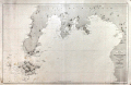 | Details | Direccion Hidrografia | 1875 |
| Isla de Mindanao |
|
Direccion Hidrografia |
|
| 1875 |
| LOC:0 |
| $0.00 | Direccion-Hidrografia | Isla-de-Mindanao | SOLD<br></br>Antique copper-plate engraved nautical chart of the southwest portion of the Philippine island of Mindanao and all of Sacol, Basilan, Olutanga, and Bongo islands. Key features include Zamboanga City, Bahia de Illana ( Illana Bay ) and Seno de Sibuguey ( Sibugay Bay ) and the Moro Gulf. The Zamboanga Peninsula is labeled "Reino de Sibuguey". Limited interior detail includes the Mindanao River, Panguil Bay, Mt. Tres Reyes, Mt. Kaladis, and Mount Silingan. On the tip of the peninsula is located a 'fuerza' or fort- the Real Fuerza de Nuestra Señora del Pilar de Zaragoza constructed by Spain beginning in 1635. With track lines shown for the course of steamship "Reina de Castilla" In 1862.
<br></br>
Published by Spain's Direccion Hidrografica from Madrid first in 1864, this issue is corrected to 1875. Plate 16 of a series of charts documenting the "Archipielago Filipino". Price when issued was 6 pesetas. Chart number 518. |
| 772 | 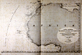 | Details | Direccion Hidrografia | 1939 |
| Spanish sea chart of West Africa |
|
Direccion Hidrografia |
|
| 1939 |
| LOC:0 |
| $325.00 | Direccion-Hidrografia | Spanish-sea-chart-of-West-Africa | Large hydrographic chart of western Africa by Spain's Hydrographic Office, the Direccion de Hidrografia. This chart was originally engraved in 1855 by Serra and updated several times after that; the latest corrections date from 1939. Coverage extends from the islands of São Tomé and Príncipe in the south up as far north as the Strait of Gibraltar and includes the Canary Islands ( Islas Canaria ) and Cape Verde Islands ( Islas de Cabo Verde ).
<br></br>
A later edition of one of four sheets published in Madrid in 1855, that could be joined to cover the entire mid Atlantic Ocean from the Americas to Europe and Africa. Number 212. |