| | Thumbnail | | Creator | Date | Title / Author / Date / Location | Price | | | Description |
| 5047 |  | Details | Dornbush, Adrian | 1935 |
| Depression era pictorial brochure 1st Edition map The Coral Isle of Key West |
|
Dornbush, Adrian |
|
| 1935 |
| LOC:500 |
| $300.00 | Dornbush--Adrian | Depression-era-pictorial-brochure-1st-Edition-map-The-Coral-Isle-of-Key-West | Two scarce maps of Key West, Florida in a visitor's guide booklet simply titled "Key West" published by the Key West Administration in 1935. The booklet is a product of the Public Works of Art Project (PWAP) during the New Deal that was succeeded by the Federal Art Project of the Works Progress Administration (WPA).
<div class="indenttextblocksingle">
"Public Works of Art Project artists from other parts of the country were brought in and put to work creating paintings, murals or public places, and other projects, such as tourist brochures and postcards." [1]
</div>
</br>
The brochure includes a fine 1st edition pictorial map (9" x 6") of Key West, Florida: "The Coral Isle of Key West" by artist Adrian Dornbush, 1935. The map (first edition) was engraved on a "miraculous" scale and shows key landmarks such as Duval Street, the lighthouse, the Martello Towers, and the yacht basin. Other FERA artists who contributed works to the brochure include Edward Bruce, Richard Sargeant, Avery Johnson, Klir Beck, and Richard Jansen.
<br></br>
At center of the brochure is an anonymous two-sheet "Map of the Lower Florida Keys or the Key West Archipelago" (18" x 6") containing a smaller inset map of the Caribbean region.
<br></br>
Printed by Orange Publishing Co. St. Cloud, Florida.
<br></br>
[1] https://keysarts.com/public_art/wpa.html <br>
[2] <a href="https://www.rarecharts.com/ShowDetail/Creator/Dornbush--Adrian/Title/Depression-era-pictorial-brochure-with-variant-2nd-Edition-map-Coral-Isle-of-Key-West/5493" target="_blank">See the second edition here.</a> |
| 5464 | 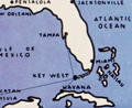 | Details | Dornbush, Adrian | 1935 |
| Depression-era pictorial map of The Coral Isle of Key West |
|
Dornbush, Adrian |
|
| 1935 |
| LOC:0 |
| $0.00 | Dornbush--Adrian | Depression-era-pictorial-map-of-The-Coral-Isle-of-Key-West | <b>SOLD</b>, but see <a href="https://www.rarecharts.com/ShowDetail/Creator/Dornbush--Adrian/Title/Depression-era-pictorial-brochure-1st-Edition-map-The-Coral-Isle-of-Key-West/5047" target="_blank">another Dornbush item</a> now in stock.
<br></br>
Two scarce maps of Key West, Florida in a visitor's guide booklet simply titled "Key West" published by the Key West Administration in 1935. The booklet is a product of the Public Works of Art Project (PWAP) during the New Deal that was succeeded by the Federal Art Project of the Works Progress Administration (WPA).
<div class="indenttextblocksingle">
"Public Works of Art Project artists from other parts of the country were brought in and put to work creating paintings, murals or public places, and other projects, such as tourist brochures and postcards." [1]
</div>
</br>
The brochure includes a fine pictorial map (9" x 6") of Key West, Florida: "The Coral Isle of Key West" by artist Adrian Dornbush, 1935. The map was engraved on a "miraculous" scale and shows key landmarks such as Duval Street, the lighthouse, the Martello Towers, and the yacht basin. |
| 5493 | 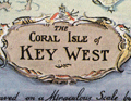 | Details | Dornbush, Adrian | 1935 |
| Public Works of Art Project brochure variant 2nd Edition map Coral Isle of Key West |
|
Dornbush, Adrian |
|
| 1935 |
| LOC:500 |
| $285.00 | Dornbush--Adrian | Public-Works-of-Art-Project-brochure-variant-2nd-Edition-map-Coral-Isle-of-Key-West | Two scarce maps including a rare presumed 2nd. "The Coral Isle of Key West" Florida in a visitor's guide booklet simply titled "Key West" published by the Key West Administration after 1935. The booklet is a product of the Public Works of Art Project (PWAP) during the New Deal that was succeeded by the Federal Art Project of the Works Progress Administration (WPA).
<div class="indenttextblocksingle">
"Public Works of Art Project artists from other parts of the country were brought in and put to work creating paintings, murals or public places, and other projects, such as tourist brochures and postcards." [1]
</div><br>
<div id="3" align="center">
<a title="Key West Booklet"></a>
<img id="3" src="/ZoomifyImages/SC_5493/SC_5493_Cover_400x300.jpg" alt="Dornbush pictorial map The Coral Isle of Key West." width="240"/>
</div>
<br />
Other FERA artists who contributed works to the brochure include Edward Bruce, Richard Sargeant, Avery Johnson, Klir Beck, and Richard Jansen.<br>
</br>
The brochure includes a fine 9" x 6" pictorial map of Key West, Florida: "The Coral Isle of Key West" by artist Adrian Dornbush, 1935. Second edition. This map is most interesting in that it is an <b>unrecorded substantial revision of Dornbush's original map of Key West.</b> This edition contains numerous changes from the first edition including:
<div class="indenttextblocksingle">
<ul>
<li>For the first time, an airport is noted in the location of Meacham Field, now Key West International Airport (EYW)</li>
<li>Seaplane ramps at Trumbull Point (labeled "Key West Airways") are replaced with ship docks. </li>
<li>Radio towers are now shown located at the island's west side near Duval Street.</li>
</ul>
</div>
The map was engraved on a "miraculous" scale and shows key landmarks such as Duval Street, the lighthouse, the Martello Towers, and the yacht basin.
<br></br> |