| | Thumbnail | | Creator | Date | Title / Author / Date / Location | Price | | | Description |
| 5422 | 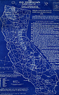 | Details | Douglas, Jack | 1948 |
| Rare blueprint prospectors map of California gold lodes |
|
Douglas, Jack |
|
| 1948 |
| LOC:90 |
| $550.00 | Douglas--Jack | Rare-blueprint-prospectors-map-of-California-gold-lodes | Very rare cyanotype (blueprint) self-published gold mining map of California by Jack Douglas (d. 1956)- "The Old Prospector's Lode Map of California." At a scale of one inch = 32 miles the map shows areas in California known to have produced gold, shown as shaded areas.
<br></br>
The map includes crude decorative images of gold panning equipment and of an old prospector at work. At bottom left a list of other gold lode district maps for sale at $1.00 each includes Alaska, Arizona, British Columbia, Idaho, Montana, Nevada, New Mexico, Oregon, Utah, Washington, and Wyoming. These could be purchased along with blueprint assembly instructions for mining equipment by Jack Douglas at Box 21, Dutch Flat, California.
<br></br>
No holdings found in WorldCat and no mention of the map is found online.
<br></br>
Text at right discusses gold mining in several California mining districts. Verso is blank. Map no. 153.
<br></br>
Jack Douglas was the founder of the United Prospectors Organization (1947), originally targeted at professionals who made their livelihood by prospecting and mining. Douglas published a journal- Panning Gold- the first issue of which was issued in 1947. United Prospector's was incorporated on November 29, 1949 with Jack Douglas as President. Other officers at the time of incorporation included Walter Robertson, Stockton, CA; Tylar Jack, Reedy, CA; Speed Freeman, Olympia Field, IL; Louis Borde, Eugene, OR; Harold Mitchell, Umatilla, OR; and Glen Houston, Lodi, CA. Today UPI is "the oldest gold, gems, and minerals prospecting group of its kind."
<br></br>
<div>
<img src="/ZoomifyImages/SC_5422/Doodle_Bug.jpg" alt="" width="200" align="left" style="margin: 0px 10px"/>
<span style="vertical-align: middle;">
Note: Price includes an additional rare blueprint (shown here) for Jack Douglas' "Doodle Bug" wet concentrator. Copyright 1944.
</span>
</div>
<br></br> |
| 8165 |  | Details | Douglas, Jack | 1948 |
| Jack Douglas's Blueprint Map of New Mexico Gold Lode Districts |
|
Douglas, Jack |
|
| 1948 |
| LOC:90 |
| $595.00 | Douglas--Jack | Jack-Douglas-s-Blueprint-Map-of-New-Mexico-Gold-Lode-Districts | Blueprint prospecting map of New Mexico by Jack Douglas, published from Box 21, Dutch Flat, California. White lettering and linework on a blue ground identify roads, county boundaries, towns, and numbered gold-bearing localities keyed to descriptions arranged by county. The map concerns gold occurring in lodes, or mineral deposits within rock, complementing Douglas's separate series of placer maps.<br><br>
The numbered entries direct prospectors to localities in Socorro, Sierra, Grant, Hidalgo, Dona Ana, Taos, and other counties. Practical cautions advise carrying a reliable road map and extra water, investigating desert ground before leaving the road, and avoiding abandoned shafts. Small illustrations of mining tools and an old prospector accompany the title.<br><br>
Issued as part of Douglas's regional gold-lode map series covering the western states and British Columbia. An advertisement offers companion maps at $1 each or three for $2 postpaid, alongside prospecting books and equipment plans. An invitation to join the United Prospectors places the publication within a wider network supplying information and assistance to amateur miners.<br><br> |
| 8166 |  | Details | Douglas, Jack | 1948 |
| Lot of Two Old Prospectors Maps for Arizona Lode and Placer |
|
Douglas, Jack |
|
| 1948 |
| LOC:90 |
| $1,100.00 | Douglas--Jack | Lot-of-Two-Old-Prospectors-Maps-for-Arizona-Lode-and-Placer | One lot of two complementary blueprint (cyanotype) maps of Arizona's gold-bearing districts, copyrighted 1948 by Jack Douglas of Dutch Flat, California. Rare. Not found in WorldCat.
<br><br>
The pair comprises his lode map, locating gold deposits within rock, and his placer map, identifying gold-bearing gravels and other loose deposits. White lettering and linework on blue grounds show towns, roads, county boundaries, and numbered prospecting localities linked to extensive directories below and beside each map.<br><br>
The lode map identifies 84 numbered localities, including districts around Prescott, Jerome, Oatman, Tombstone, and the Bradshaw Mountains. Entries are grouped by county, with reported county gold yields and directions from nearby settlements. The placer map similarly provides a county-by-county guide, including workings around Wickenburg, Quartzsite, the Colorado River, and the streams of Yavapai County. Together the sheets document two distinct approaches to finding gold across Arizona.
<br><br>
Published as nos. 151 and 142 in Douglas's respective lode and placer map series, which covered the western states and British Columbia. Marginal advertisements offer companion maps for $1 each or three for $2 postpaid, promote his books "Gold in Placer" and "Gold in Lode," and encourage membership in the United Prospectors organization. Practical cautions address desert travel and water supplies; notices explain that past gold discoveries do not guarantee either further finds or permission to work the ground. Small mining-tool illustrations and a vignette of an old prospector complete the designs.
<br><br> |
| 8161 |  | Details | Douglas, Jack | 1948 |
| Very Rare Blueprint Map of Nevada Gold Placers by Jack Douglas |
|
Douglas, Jack |
|
| 1948 |
| LOC:90 |
| $595.00 | Douglas--Jack | Very-Rare-Blueprint-Map-of-Nevada-Gold-Placers-by-Jack-Douglas | Very rare cyanotype (blueprint) map of Nevada's gold placer districts, published in 1948 by Jack Douglas, "The Old Prospector," of Dutch Flat, California. Designed for independent prospectors and self-published, the map identifies numbered locations where placer gold had been found, keyed to county-by-county descriptions with directions and distances from nearby settlements. Towns, rivers, county boundaries, and principal highways provide the geographic framework.<br><br>This Nevada sheet is number 139 in Douglas's advertised series of thirteen placer maps, numbered 137 through 149, covering eleven western states, Alaska, and British Columbia. Offered at $1 each or three for $2, postpaid, the series provided affordable geographic guides to reported gold occurrences. Douglas also published separate lode maps, including California map number 153, distinguishing deposits in bedrock from placer gold in loose gravel and sediment.<br><br>The Nevada directory includes Rabbit Hole, Rosebud, and Placeritas in Pershing County; Manhattan and Round Mountain in Nye County; and Eldorado near Nelson in Clark County. An entry near Las Vegas records placer ground submerged beneath Lake Mead. Additional notes acknowledge gold in bedrock crevices and caution that a reported occurrence does not guarantee permission to prospect.<br><br>Practical instructions advise motorists to inquire locally before leaving numbered highways, carry extra water, and place brush beneath tires when bogged down. Crossed mining tools, a compass indicator, and a small prospector illustration decorate the sheet. Advertisements promote Douglas's book "Gold in Placer" and membership in the United Prospectors organization, placing the map within his broader program of publications and support for small-scale gold seekers.
<br><br> |