| | Thumbnail | | Creator | Date | Title / Author / Date / Location | Price | | | Description |
| 905 | 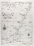 | Details | Dudley, Robert | 1646 |
| Fine Antique Nautical Chart of Scotland with Edinburgh |
|
Dudley, Robert |
|
| 1646 |
| LOC:89 |
| $2,400.00 | Dudley--Robert | Fine-Antique-Nautical-Chart-of-Scotland-with-Edinburgh | Rare and extremely desirable first edition nautical chart of the east coast of Scotland including coastline for all or part of the following Scottish council areas : the Lothians, Fife, Angus, Aberdeenshire, Moray ("Costa di Muray"), and Highland.
<br></br>
This antique sea chart is from the <b>Dell' Arcano del Mare</b> published from Florence in 1646 by Sir Robert Dudley, the illegitimate son of Robert Dudley, 1st Earl of Leicester and a close friend of Elizabeth I. Dudley was an adventurer, explorer, naval advisor to the Grand Duke of Tuscany, and publisher. The charts have a unique sparse Baroque style that is complemented by very high quality calligraphy and engraving (by Lucini). In addition to the quality of execution, charts from the Arcano del Mare are highly sought after for their singularity- as the <b>first maritime atlas to cover the entire globe</b>, the first world atlas published by an Englishman, and the first maritime atlas to use the Mercator projection.
<br></br>
There are many named settlements in Scotland on this old chart including: Dunbar, Edinburgh ("Edenburgh"), Dundee ("Donde"), <b>St. Andrews or "S. Andrea" (of golfing legend)</b> , Aberdeen ("Alberden"), Peterhead ("Peter Polle"), Spey Bay ("Spyn"), Rosemarkie ("Rosemark") . Kinloss ("Killos"). At the far north the chart ends at Cromarty ("C. di Comar").
<br></br>
In much the same way as Wagenhaer exaggerated certain features on his charts, so too the mouths of firths, bays, and rivers are not to scale. By depicting them at a larger scale, Dudley is able to obtain some of the benefits of a large-scale chart in what is otherwise a small-scale chart of the area. |