| | Thumbnail | | Creator | Date | Title / Author / Date / Location | Price | | | Description |
| 5296 | 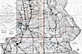 | Details | Dunwody, William E. | 1922 |
| Earliest map of Charlotte, Glades, Hardee, Highlands counties Florida after DeSoto redivision |
|
Dunwody, William E. |
|
| 1922 |
| LOC:87 |
| $225.00 | Dunwody--William-E- | Earliest-map-of-Charlotte--Glades--Hardee--Highlands-counties-Florida-after-DeSoto-redivision | Map of DeSoto, Charlotte, Glades, Hardee, and Highlands counties in Florida ca. 1922. In 1921 the Florida legislature created the latter four counties out of what had previously been DeSoto County. Possibly the earliest map containing the names of those four new counties. Map is a Fotoprint printed by Foote & Davies Co, Atlanta.
<br></br>
Published by William Elliott Dunwody (1882-1956) a businessman in Arcadia, Florida, the seat of DeSoto County. Dunwody had interests in real estate, ranching, and citrus farming, and was Chairman of the local Selective Service Board from 1941 to 1954.
<br></br>
Interesting in that before this Fotoprint was produced a base plat map was edited in manuscript (by Dunwody ?) to show the new county boundaries and features: roads, railroads, towns, lakes; and type of terrain: swamp and muck, pine, or prairie. This item is a product of that enhancement made just after the new counties were created.
<br></br>
It is ironic that at center left, in one of the marked swampy areas, a manuscript notation is made: <b>"Red dot within green circle represents location your 10 acres."</b> Lucky guy! Key features include the Kissimmee River, Lake Istokpoga, Lake Okeechobee, Charlotte Harbor, and two airbases built in 1917 during early WWI: Carlstrom Field, and Dorr Field. |