| | Thumbnail | | Creator | Date | Title / Author / Date / Location | Price | | | Description |
| 724 | 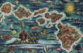 | Details | Feher, Joseph | 1950 |
| Dole Map of the Hawaiian Islands |
|
Feher, Joseph |
|
| 1950 |
| LOC:0 |
| $0.00 | Feher--Joseph | Dole-Map-of-the-Hawaiian-Islands | This map of Hawaii by Joseph Feher has been <b>sold</b> but in our inventory we now have one additional <a href=" https://www.rarecharts.com/ShowDetail/Creator/Feher--Joseph/Title/The-Dole-Map-of-the-Hawaiian-Islands/4983" target="_blank">Dole pictorial map of the Hawaiian Islands</a>.
<br></br>
Joseph Fehér (b. 1908) was a watercolorist active in Hawaii from about 1930 - 1960. Feher’s travel-related work was in demand for decades and included promotional posters and calendars for United Airlines and other corporate clients. |
| 4983 |  | Details | Feher, Joseph | 1950 |
| The Dole Map of the Hawaiian Islands |
|
Feher, Joseph |
|
| 1950 |
| LOC:63 |
| $0.00 | Feher--Joseph | The-Dole-Map-of-the-Hawaiian-Islands | SOLD<br><br> Original lithographed pictorial map of the Hawaiian Islands copyrighted by the Hawaiian Pineapple Company Ltd. 1950. Overall width 40.5 inches. Includes original legend at right. Pinholes in margins. Loose. Not laid down. No stains.
<br><br>
Artist Joseph Feher depicted the Hawaiian islands and adjacent waters with boats, fish, and typical objects and pursuits associated with the islands: flying fish, surfing, spear fishing, sailing, poi-making, hula dancers, etc. Islands of the State of Hawaii mentioned in the legend include: Kauai, Niihau, Oahu, Molokai, Lanai, Maui, Kahoolawe, and the big island- Hawaii.
<br></br>
This is the second of two "Dole Pineapple Maps", the first was published in 1937.
<br></br>
Lithography by Schwabacher-Frey.
<br></br>
Once known as the Sandwich Islands, the Hawaiian Islands first documented discovery by a westerner occurred in 1778 with the arrival of British explorer Captain James Cook.
<br></br> |
| 8090 |  | Details | Feher, Joseph | 1950 |
| The Dole Map of the Hawaiian Islands |
|
Feher, Joseph |
|
| 1950 |
| LOC:63 |
| $575.00 | Feher--Joseph | The-Dole-Map-of-the-Hawaiian-Islands | Original lithographed pictorial map of the Hawaiian Islands copyrighted by the Hawaiian Pineapple Company Ltd. 1950. Overall width 40.5 inches. Lacking original legend at right. Pinholes in margins.
<br><br>
Artist Joseph Feher depicted the Hawaiian islands and adjacent waters with boats, fish, and typical objects and pursuits associated with the islands: flying fish, surfing, spear fishing, sailing, poi-making, hula dancers, etc. Islands of the State of Hawaii mentioned in the legend include: Kauai, Niihau, Oahu, Molokai, Lanai, Maui, Kahoolawe, and the big island- Hawaii.
<br></br>
This is the second of two "Dole Pineapple Maps", the first was published in 1937.
<br></br>
Lithography by Schwabacher-Frey.
<br></br>
Once known as the Sandwich Islands, the Hawaiian Islands first documented discovery by a westerner occurred in 1778 with the arrival of British explorer Captain James Cook.
<br></br> |