| | Thumbnail | | Creator | Date | Title / Author / Date / Location | Price | | | Description |
| 565 | 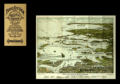 | Details | Finn, W.J. | 1917 |
| Birds Eye View of Boston Harbor |
|
Finn, W.J. |
|
| 1917 |
| LOC:0 |
| $0.00 | Finn--W-J- | Birds-Eye-View-of-Boston-Harbor | SOLD <br></br>
Folding antique colored harbor excursion map from ca. 1917 of South Boston, Boston Harbor, Dorchester Bay, Quincy Bay, and Cape Cod Bay to Provincetown. Shows steamship routes to coastal towns and identifies many nearby islands. This map could have been purchased by passengers aboard any steamboat plying the routes shown on the attached map. <BR> </BR>
Without the advertisements sometimes found on the cover. Price is noted on the front as "10 cents". |
| 1005 | 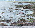 | Details | Finn, W.J. | 1917 |
| Birdseye View of Boston Harbor by Union News Co. |
|
Finn, W.J. |
|
| 1917 |
| LOC:200 |
| $240.00 | Finn--W-J- | Birdseye-View-of-Boston-Harbor-by-Union-News-Co- | Folding antique colored harbor excursion map from ca. 1917 of South Boston, Boston Harbor, Dorchester Bay, Quincy Bay, and Cape Cod Bay to Provincetown. This colorful survivor shows steamship routes to coastal towns and identifies many nearby islands.
<br></br>
This map could have been purchased by passengers aboard any steamboat plying the routes shown on the map including:
<div class="indenttextblock">
<ul style="list-style-type: circle;">
<li>To Europe</li>
<li>To Provincetown</li>
<li>To Plymouth</li>
<li>To Nantasket</li>
<li>To New York</li>
</ul>
</div>
Legend at bottom identifies numerous islands and other features as a sample below illustrates:
<div class="indenttextblock">
<ul style="list-style-type: circle;">
<li>Nixes Mate</li>
<li>Snake Island</li>
<li>Commonwealth Pier</li>
<li>Minots Light</li>
<li>Rowes Wharf</li>
</ul>
</div>
Without the advertisements sometimes found on the cover. Price is noted on the front as "10 cents". |