| | Thumbnail | | Creator | Date | Title / Author / Date / Location | Price | | | Description |
| 6350 | 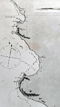 | Details | Fitz Roy, Robert | |
| Admiralty chart from 2nd Beagle Voyage along coastal Peru. |
|
Fitz Roy, Robert |
|
|
| LOC:67 |
| $365.00 | Fitz-Roy--Robert | Admiralty-chart-from-2nd-Beagle-Voyage-along-coastal-Peru- | Scarce original antique nautical chart of a portion of the coast of Peru between the Chicama River and Port Payta (Paita). A copper-plate engraving of a sea chart made under the auspices of Captain Robert Fitz Roy, R.N. (1805-1865) and the Officers of HMS Beagle.
<b>An important artifact from the hydrographic survey of the west coast of Peru made aboard the HMS Beagle on its second voyage, accompanied by Charles Darwin (1809 – 1882) as Naturalist. </b>
<br></br>
Traces of use at sea include manuscript track and bearing lines in pencil below Sechura Bay from the island of Lobos de Tierra to the island of Lobos de Afuera. Five finely engraved attractive inset elevation coastal views as seen from offshore.
<br></br>
Inset map of Point Eten based on an 1870 survey by a group including the H.M.S. Cameleon. A small warning that Eten Point is laid down on the map six miles east of its actual position.
<br></br>
Survey was conducted in 1836. First published by the British Admiralty on January 26, 1841 Last correction in December 1870. Engraved by J&C Walker. Sold by Potter. Chart # 1335. |