| | Thumbnail | | Creator | Date | Title / Author / Date / Location | Price | | | Description |
| 3672 | 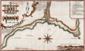 | Details | Frezier, Amedee | 1717 |
| Plan of the anchorage at Ilo, Peru |
|
Frezier, Amedee |
|
| 1717 |
| LOC:77 |
| $325.00 | Frezier--Amedee | Plan-of-the-anchorage-at-Ilo--Peru | Frezier's plan of the Peruvian port city of Ilo (Ylo), the capital of Ylo province. Frezier made a reconnaissance mission to the coast of South America from 1712-1714. Posing as a trader or merchant captain, Frezier sketched harbor defenses and gathered information on the military preparedness of each port visited.
<br></br>
Includes a coastal elevation view and several drawings of a mill probably for sugar cane. Key at top right relates to locations identified on the plan. North is oriented to the left.
<br></br>
Amédée Frézier (1682 – 1773) was an French explorer, military engineer, mathematician, and spy. This plan of Ylo, Peru is from Frezier's 1717 account of his travels published in French in 1717: "Relation du voyage de la mer du Sud, aux côtes du Chili, du Pérou et de Brésil, fait pendant les années 1712, 1713, et 1714". |
| 5162 | 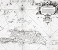 | Details | Frezier, Amedee | 1725 |
| Isle de S. Domingue |
|
Frezier, Amedee |
|
| 1725 |
| LOC:51 |
| $300.00 | Frezier--Amedee | Isle-de-S--Domingue | Map of the island of Hispaniola by Amedee Francois Frezier (1682-1773). Includes portions of the Bahamas, Cuba, Jamaica, and Puerto Rico. Decorative dedicatory cartouche.
<br><?br>
Includes an inset plan "Plan de la Ville Espagnole de S. Domingue". Condition issues at right margin but should mat and frame nicely. |