| | Thumbnail | | Creator | Date | Title / Author / Date / Location | Price | | | Description |
| 8059 | 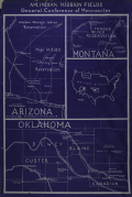 | Details | General Council of Mennonites | 1930 |
| Native Americans Map of Mennonite Missions Interwar Period |
|
General Council of Mennonites |
|
| 1930 |
| LOC:141 |
| $500.00 | General-Council-of-Mennonites | Native-Americans-Map-of-Mennonite-Missions-Interwar-Period | A sigular cyanotype blueprint map issued by the General Conference of Mennonites (GCM) in the late 1920s or early 1930s, this map titled AM. Indian Mission Fields was created as an institutional planning and promotional tool rather than a conventional geographic survey. The map shows roads, towns, GCM fields, and GCM missions in three states: Montana, Arizona, and Montana. An inset map of the United States shows the relative locations of the GCM missions within the United States. Tribes located on the map include the Hopi, Leupp, Cheyenne, the Cheyenne Arapaho, and Navajo.
<br><br>
The map translates complex Indigenous homelands into legible service areas, emphasizing responsibility, access, and administration. What it includes, and what it leaves out, reflects the priorities of the organization that produced it, revealing how Native American lands were visually redefined to support religious outreach and oversight rather than Indigenous sovereignty.<br><br>
Infrastructure plays a central role in this reframing. The map is organized around highways, including the newly established U.S. numbered routes of the late 1920s, transforming Native space into a network of reachable points connected by automobile travel. Roads function here not simply as transportation features but as the map’s underlying logic, normalizing mobility, circulation, and regular visitation. In doing so, the map aligns missionary work with the broader integration of Native regions into national systems of movement and administration during the Route 66 era.<br><br> |