| | Thumbnail | | Creator | Date | Title / Author / Date / Location | Price | | | Description |
| 8060 | 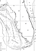 | Details | Goode, G. Brown | 1887 |
| Late 19th Century Map of Gulf Coast Fishing Grounds |
|
Goode, G. Brown |
|
| 1887 |
| LOC: |
| $165.00 | Goode--G--Brown | Late-19th-Century-Map-of-Gulf-Coast-Fishing-Grounds | An early federal fisheries chart of the northern Gulf of Mexico titled <i>Fishing Grounds of the Gulf Coast of the United States</i> (Chart No. 16), covering the coast from the Mississippi Delta and Mobile Bay east to the Florida Keys and Cape Canaveral. The map plots depth soundings in fathoms and outlines key offshore banks and ledges, with dotted boundaries marking the reported limits of the red snapper and grouper fishing grounds. Notes identify the operating ranges of Gulf fishing smacks and indicate principal fishery localities along the shore, capturing a working geography of the region at the height of nineteenth century commercial sail fisheries.<br><br>
Issued as part of the U.S. Fish Commission publication <i>The Fishery Industries of the United States</i> (Section III), the sheet is significant as an early attempt to translate fishermen's local knowledge into a standardized, survey-like document. It helped define where high value reef and bottom fisheries were concentrated relative to depth and distance offshore, information central to the expansion of long range Gulf fishing and the emerging national seafood trade. Today it also serves as a baseline record of fishing grounds and practices before twentieth century industrialization, making it valuable for historians of American maritime economy and for long term environmental comparison.
<br><br>
"The Fishery Industries of the United States". 1887. Section 3. Page 62.<br><br> |