| | Thumbnail | | Creator | Date | Title / Author / Date / Location | Price | | | Description |
| 6529 | 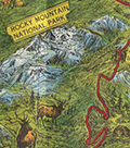 | Details | Green, Walter O. | 1951 |
| Western style pictorial map of the Colorado Rocky Mountains |
|
Green, Walter O. |
|
| 1951 |
| LOC: |
| $375.00 | Green--Walter-O- | Western-style-pictorial-map-of-the-Colorado-Rocky-Mountains | Interesting and scarce pictorial folding motor-tour map of a portion of Colorado near the Rocky Mountain National Park from 1951. Includes Boulder, Estes Park and much more in a western style complete with horse-riding cowboys, bucking broncos, and wizened prospectors. A serious map, not a hint of humor. Issued by the Rocky Mountain Motor Company, Denver, Colorado in 1951. Map by Walter O. Green.
<br><br>
Towns and cities on the map include:
<div class="indenttextblocksingle">
<ul style="list-style-type: circle;"></li>
<li>Denver</li>
<li>Evergreen</li>
<li>Golden</li>
<li>Boulder</li>
<li>Granby</li>
<li>Grand Lake</li>
<li>Estes Park</li>
<li>Fort Collins</li>
<li>Greely</li>
<li>Longmont</li>
<li>Lyons</li>
</ul>
</div>
Verso with color photographs, text, and motor tour schedules.
<br><br>
Green also identifies numerous geographical features
<div class="indenttextblocksingle">
<ul style="list-style-type: circle;"></li>
<li>Big Thompson Canyon</li>
<li>Iceberg Lake</li>
<li>Grand Lake</li>
<li>Arapaho Peak Elev. 13506 Ft.</li>
<li>Longs Peak Elev. 14255 Ft.</li>
<li>Red Rocks</li>
<li>Mount Evans Elev. 14360 Ft.</li>
<li>Berthoud Pass</li>
</ul>
</div> |