| | Thumbnail | | Creator | Date | Title / Author / Date / Location | Price | | | Description |
| 7941 | 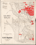 | Details | Hagelstein, G. and C. | 1924 |
| Map of Lake Medina Highlands lodge and camp sites, San Antonio |
|
Hagelstein, G. and C. |
|
| 1924 |
| LOC:41 |
| $0.00 | Hagelstein--G--and-C- | Map-of-Lake-Medina-Highlands-lodge-and-camp-sites--San-Antonio | SOLD<br><br>Cadastral plat map and sales advertisement ("Absolute Auction Sale") of Lake Medina Highlands lodge and camp sites, San Antonio, Texas. Shows a planned recreational and residential development on the shores of Medina Lake in the Texas Hill Country, Bandera County, Texas. Dated within to 1924.<br><br>
Red shading marks lots that were already sold or reserved at the time of printing, a common marketing device for sales maps. A certification block from a Bexar County surveyor confirms the survey’s accuracy and filing with local authorities. The plotted lots are numbered, and circular survey reference marks (with numbers inside) indicate the original survey tracts or blocks.
<br><br>
Medina lake forms a broad crescent stretching west to east, measuring about 18 miles in length and up to 3 miles across at its widest point. It is impounded by Medina Dam at the southern end—a structure that, when completed in 1913, was the largest concrete dam in the United States and the fourth largest dam overall. The dam's significance was recognized in 1976 when it was placed on the National Register of Historic Places.
<br><br>
Verso with a small inset map and details for an auction of the sites by Barry and Austin, Auctioneers. |