| | Thumbnail | | Creator | Date | Title / Author / Date / Location | Price | | | Description |
| 6661 | 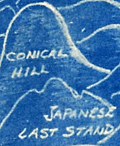 | Details | Henshell, J. | 1945 |
| Cyanotype pictorial map of Okinawa, Japan post WWII |
|
Henshell, J. |
|
| 1945 |
| LOC:86 |
| $350.00 | Henshell--J- | Cyanotype-pictorial-map-of-Okinawa--Japan-post-WWII | This is an original, rare cyanotype blueprint map, self published by J. Henshell, likely a soldier stationed on Okinawa, Japan. It depicts a birds-eye view of the Island of Okinawa, Japan and is dated November 1945, just three months after the surrender of Japan, or V-J Day (1). Henshell's design showcases his appreciation for local Okinawan art and culture, depicting shrines, temples, and tombs in a local artistic style. Local airfields and airbases are shown in rectangular boxes (e.g. Kadena, Futema, Yontan). After a Japanese Imperial Land Survey conducted in 1931.
<br><br>
The design also highlights the hills that played a significant role in the Battle of Okinawa. The island's rugged terrain made them difficult to attack. American forces faced fierce resistance from entrenched Japanese defenders during the battle. Henshell labels three of these key locations: Sugar Loaf Hill, the Conical Hill (Mount Yaedake), and the Japanese Last Stand.
<br><br>
Sugar Loaf Hill was a heavily fortified Japanese defensive position that played a significant role in the Battle of Okinawa. Today, it is a peaceful park and memorial site called the Okinawa Peace Memorial Park. The transformation of Sugar Loaf Hill from battlefield to symbol of peace is a testament to the strength of the people of Okinawa.
<br><br>
Mount Yaedake, also known as Conical Hill, was a key location in the Battle of Okinawa during World War II, as it was heavily fortified by Japanese defenders and provided a natural defensive position. Today, Mount Yaedake is a popular tourist destination, known for its stunning views of the surrounding area.
<br><br>
<div class="indenttextblock">
(1) Nakagusuku Bay, located on the eastern coast of Okinawa, was renamed Buckner Bay in honor of Lieutenant General Simon Bolivar Buckner Jr., who served as commanding General US Army's 10th Army Division during the Battle of Okinawa. Buckner was the highest-ranking US officer to be killed during the battle.
</div> |