| | Thumbnail | | Creator | Date | Title / Author / Date / Location | Price | | | Description |
| 7952 | 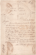 | Details | Hill, William | 1786 |
| Rare Headright Plat of Cedar Island Oconee River Georgia |
|
Hill, William |
|
| 1786 |
| LOC:78 |
| $990.00 | Hill--William | Rare-Headright-Plat-of-Cedar-Island-Oconee-River-Georgia | Extremely rare pen and ink manuscript map of Cedar Island, Georgia signed by Thomas McCall (1), Surveyor General of Georgia, just two years before the colony became the fourth state to enter the Union when it ratified the U.S. Constitution on January 2, 1788. The plat survey, conducted March 20, 1786, was related to a warrant issued by Senior Justice Jared Irwin (2), just two years after Washington County was created from land ceded by two treaties with the Creek and Cherokee native Americans in 1783.
<br><br>
The true location of Cedar Island is speculative but, at the top of the document is a drawing of the Cedar Island plat, bisected by a survey line where the two end points were a white oak tree and a cypress tree. The island lies surrounded on all four sides by the Oconee river, and with other properties outside the boundaries, including “Indian Land” at the north. The text reads:
<br><br><div class="indenttextblocksingle">
“Pursuant to a Warrant under the hand of the Honorable Jared Irwin esquire Senior Justice presiding at … court ... in Washington County. Dated March 6,1786. Was Surveyed for Charnill Wallis, who resides in this State a Tract of Land containing Six Hundred Acres in Oconee River called Ceder Island: - Having such form & marks, as are expected in the above plat. Surveyed March 20, 1786 by Jno. Hill D.S. & certified by Saml. Camp pro. b. Surveyor."</div>
<br> |