| | Thumbnail | | Creator | Date | Title / Author / Date / Location | Price | | | Description |
| 5229 | 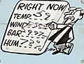 | Details | Hoff, P. J. | 1956 |
| Early Television Weather Map P. J. Hoff Chicago WBBM Channel 2 |
|
Hoff, P. J. |
|
| 1956 |
| LOC:53 |
| $770.00 | Hoff--P--J- | Early-Television-Weather-Map-P--J--Hoff-Chicago-WBBM-Channel-2 | Rare manuscript television weather map for the Chicago, Illinois area from Friday, September 14, 1956, "a treasure of broadcasting history" (1). A cartoon-like map with a very unusual mechanical enhancement (string) for animating the map that foreshadows later computer-generated animation of TV weather maps.
<br></br>
No maps by P.J. Hoff are found in WorldCat.
<br><br>
This manuscript map was drawn during the early days of television by P. J. Hoff, one of Chicago's best known TV's personalities, at WBBM Channel 2. Hoff was known for his large weather maps drawn with a black wide-tipped marker and populated with two-dimensional cut-outs representing weather features: clouds, raindrops, umbrellas, suns, and an assortment of cartoon characters including Nanook North Wind, Susanna South Wind, and "The Vice President in Charge of Looking Out the Window."
<br></br>
Here the "V.P." is fashioned with two strings to permit the character to be pulled though a wringer with a bucket at the bottom labeled "H 2 0". All in fun to illustrate the forecast for rain. At right, a Chinese character promises more of the same weather in the eastern part of the weather area: "Allee Samee Okley You Sneeze." Today that stereotype would be considered politically incorrect.
<br></br>
With an ink MS dedication by Hoff to David Rowley.
<br></br> |