| | Thumbnail | | Creator | Date | Title / Author / Date / Location | Price | | | Description |
| 1061 | 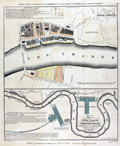 | Details | House of Commons | 1803 |
| 1803 plans of the Thames River docks and proposed construction |
|
House of Commons |
|
| 1803 |
| LOC:89 |
| $425.00 | House-of-Commons | 1803-plans-of-the-Thames-River-docks-and-proposed-construction | Two plans from early 1800's of the docks along the River Thames, the upper plan showing the Thames between London Bridge and the Tower of London. Lower map showing from London Bridge downstream past the Isle of Dogs. Part of the area now comprises the London Docklands, a center for redevelopment and urban renewal. Includes the location of the recently constructed Canary Wharf business district in the bend of the Thames River called the Isle of Dogs (once referred to as Stepney Marsh).
<br></br>
Two hand-colored maps of one sheet: a) Extension of the legal quays &c. and b) Plan of the River Thames with the proposed docks at Rotherhithe and in the Isle of Dogs for 814 ships with room for shifting and lighters.
<br></br>
Sourced from Appendix 3 and 4 of volume XIV of the Report (1796) "On Providing Accommodation for the Trade and Shipping of the Port of London". The report, ordered by the House of Commons was printed in 1796 and reprinted in 1803 by Luke Hansard and Sons, printers. |