| | Thumbnail | | Creator | Date | Title / Author / Date / Location | Price | | | Description |
| 5333 | 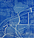 | Details | Howell and Graves | 1925 |
| Early blueprint plat map for Muscle Shoals, Alabama |
|
Howell and Graves |
|
| 1925 |
| LOC:53 |
| $275.00 | Howell-and-Graves | Early-blueprint-plat-map-for-Muscle-Shoals--Alabama | Rare blueprint map of Muscle Shoals Center Number Twelve Colbert County, Alabama. The map was part of a large development planned for the area.
<br><br>
Produced ca. 1925 by A. L. Howell and C. T. Graves Owners and Developers. Detroit, Michigan. Executive Office 350 Madison Avenue, New York, N. Y.
<br><br> |
| 7868 | 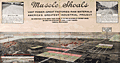 | Details | Howell and Graves | 1925 |
| Muscle Shoals, Alabama City of Unlimited Opportunity |
|
Howell and Graves |
|
| 1925 |
| LOC:130 |
| $450.00 | Howell-and-Graves | Muscle-Shoals--Alabama-City-of-Unlimited-Opportunity | Muscle Shoals, Alabama, a small city nestled along the Tennessee River, is perhaps best known today for its outsized influence on American music. The iconic "Muscle Shoals Sound," born in the city's legendary recording studios, has left an indelible mark on genres ranging from soul and R&B to rock and country.
<br><br>
But a century ago, Muscle Shoals was the epicenter of a different kind of boom - one fueled by grand industrial ambitions and the promise of a brighter future.
<br><br>
In the 1920s, automotive pioneer Henry Ford set his sights on transforming the sleepy Alabama town into a bustling metropolis to rival Detroit (1). The centerpiece of this vision was the Wilson Dam, a hydroelectric marvel that would provide cheap, abundant power to fuel the growth of industry.
<br><br>
Sensing an opportunity, New York City developers Howell and Graves began heavily promoting Muscle Shoals as the "City of Unlimited Opportunity." This advertising brochure, circa 1925, with a rare birds-eye view map showcases their grand plans. The map, which stretches from Seven Mile Island to the Wilson Dam, depicts a thriving industrial landscape, with the Tennessee River winding majestically in the background.
<br><br>
At the time, nitrate plants were the region's biggest employers, and the promise of readily available electricity was expected to lure even more manufacturers to the area. Howell and Graves themselves invested heavily in the city's future, constructing the first City Hall, homes, and the Howell and Graves Jr. High School, which still stands today as a Board of Education building.
<br><br>
However, the grand vision for Muscle Shoals was not to be. Much of the infrastructure built by Howell and Graves went unused as the Great Depression stifled the city's growth. The promised industrial boom never materialized, and Muscle Shoals settled into a quieter existence.
<br><br> |
| 6561 | 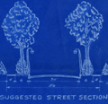 | Details | Howell and Graves | 1930 |
| Florence Alabama Lakeside Highlands Blueprint Plat Map Muscle Shoals |
|
Howell and Graves |
|
| 1930 |
| LOC:53 |
| $300.00 | Howell-and-Graves | Florence-Alabama-Lakeside-Highlands-Blueprint-Plat-Map-Muscle-Shoals | Rare original blueprint plat map of the Lakeside Highlands subdivision on the east side of Lake Wilson in the Muscle Shoals District at Florence in Lauderdale County, Alabama. With a small scale inset context map (1 inch = 1 mile): "Muscle Shoals District Showing Location of Lakeside Highlands." G.P. Nicolopoolos Owner and Developer. Date ca. 1930.
<br><br>
Drawn by W.A. Dealy, the map includes insets of a suggested tree-lined street section and a suggested business section designed by landscape architect Frank M. Button ("The highest type of Architecture is our aim.") Streets shown include the existing Lee Highway and Wilson Dam Highway (South Wilson Dam Road), and the proposed Center Drive, Shoals Boulevard, and Lakeside Drive, East Lakeside Drive and two bridle paths.
<br><br> |