| | Thumbnail | | Creator | Date | Title / Author / Date / Location | Price | | | Description |
| 3651 | 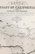 | Details | Imray, James | 1849 |
| Fine gold-rush era blueback chart of California |
|
Imray, James |
|
| 1849 |
| LOC:1409 |
| $3,900.00 | Imray--James | Fine-gold-rush-era-blueback-chart-of-California | California gold-rush era blueback chart of the West Coast from the harbor of San Blas in Mexico heading north past San Francisco Bay. Coverage includes the Gulf of California and the Baja Peninsula. A wide nautical chart in landscape orientation.
<br></br>
Includes six insets and eight stunning coastal views. The insets include: "Entrance of San Francisco Harbour"; "Harbour of San Francisco By Capn. F.W. Beechey R.N. F.R.S."; and "Bay of Monterey By M. de Tessan of the French Navy." Also, Magdalen Bay, Mazatlan, and Guaymas.
<br></br>
Published by James Imray, Chart and Nautical Book Publisher 102, Minories. 1849.
<br></br>
During the 1800's there was a trend toward publication of very large small-scale charts with large-scale insets of key passages and harbors. The practice was driven as much by economics as any other reason. One chart could replace a dozen smaller charts. James Imray and Son was one of a handful of British publishers who specialized in these charts which were often backed with canvas or linen cloth or heavy blue paper in order to help them withstand the frequent use and abuse aboard ship, hence the term "blueback chart". |