| | Thumbnail | | Creator | Date | Title / Author / Date / Location | Price | | | Description |
| 6807 | 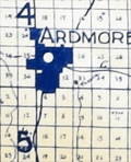 | Details | Innes, Frederick A. | 1917 |
| Map of Oklahoma producing oil and gas fields blueline |
|
Innes, Frederick A. |
|
| 1917 |
| LOC:400 |
| $0.00 | Innes--Frederick-A- | Map-of-Oklahoma-producing-oil-and-gas-fields-blueline | SOLD<br><br>Rare, large comprehensive one-sheet cloth map of producing oil and gas fields in Oklahoma from 1917. Copyright 1917 by F. A. Innes, Tulsa Oklahoma. Published by the Kelley Map Company, Tulsa, Oklahoma.
<br><br>
Manuscript pencil notation at bottom about recorded deeds in 1947. Manuscript red marks below Oklahoma City in Cleveland County possibly reflect sites for the deeds.
<br><br>
The era in which this map was produced was one of rapid growth in Oklahoma oil and gas exploration, driven in part by the demands of WWI. In 1917 Phillips Petroleum Company was incorporated in Bartlesville, Oklahoma. During 1918 the Southwestern Association of Petroleum Geologists, established just one year earlier, became the American Association of Petroleum Geologists (AAPG).
<br><br>
Type of well is denoted on the map using symbols explained in a legend for: <br><br>
<div class="indenttextblocksingle">
<ul style="list-style-type: circle;">
<li>Oil wells</li>
<li>Gas wells</li>
<li>Abandoned wells</li>
<li>Dry holes</li>
<li>Drilling wells</li>
</ul>
</div>
<br>
Photographed in two sections to accommodate size. |