| | Thumbnail | | Creator | Date | Title / Author / Date / Location | Price | | | Description |
| 7979 | 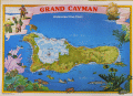 | Details | International Map Services Ltd. | 1975 |
| Grand Cayman Island Underwater Dive Chart |
|
International Map Services Ltd. |
|
| 1975 |
| LOC:86 |
| $175.00 | International-Map-Services-Ltd- | Grand-Cayman-Island-Underwater-Dive-Chart | Unrecorded fine pirate-themed chart of underwater dive sites in the Cayman Island ca. 1975.
Grand Cayman is the largest of the three Cayman Islands, which are a British Overseas Territory in the western Caribbean Sea. The map is specifically an "Underwater Dive Chart," highlighting various dive sites, dive shops and marine life around the island.
<br><br>
Some of the many dive sites noted include: New Tarpon Alley, Hepps Pipeline, Pinnacle Rock, Bonnie's Arch, Oro Verde Wreck, Balboa Wreck, Japanese Gardens, and East End Reefs.
<br><br>
Also noted is Bob Soto's diving shop. Bob Soto (1926–2015), known as the “Father of Diving” in the Cayman Islands, died at age 88, prompting dive flags to fly at half-mast across the islands. He founded recreational scuba diving in the Cayman Islands when he opened the first dive shop on George Town’s waterfront in 1957, starting with one wooden boat, several tanks, and a small staff he personally trained. Soto’s pioneering efforts created the foundation of Cayman’s world-renowned dive industry, mentoring many of today’s dive leaders.
<br><br>
Copyright International Map Services Ltd. P.O. Box 2187. Cayman Islands, B.W.I. "International Map Services Ltd." was a small company based in George Town, Grand Cayman, Cayman Islands, and was involved in the map publishing industry. |