| | Thumbnail | | Creator | Date | Title / Author / Date / Location | Price | | | Description |
| 790 | 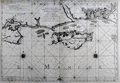 | Details | Jaillot, Alexis-Hubert | 1693 |
| Antique chart of English Coast with Poole, Isle of Wight, Christchurch, Portsmouth |
|
Jaillot, Alexis-Hubert |
|
| 1693 |
| LOC:0 |
| $1,450.00 | Jaillot--Alexis-Hubert | Antique-chart-of-English-Coast-with-Poole--Isle-of-Wight--Christchurch--Portsmouth | Large, bold, antique nautical chart of the south coast of England including portions of the counties of Dorset ( Dorchester ), Hampshire ( Southampton ), and Sussex. Dark, graphically pleasing impression with numerous rhumb lines and three extremely decorative compass roses. Coverage includes Wareham, Brownsea Island, Poole Harbor, Swanage Bay ( Baye de Sandwich ) , Christchurch, Nash, Milford, Lymington, Southampton River, Portsea Island and Portsmouth, Hayling Island, and Thorney Island, and the Harbor of Chichester.
<br></br>
From the NEPTUNE FRANÇOIS, entitled: "Le Neptune François ou Atlas des Cartes Marines Levées et Gravées par Ordre Exprés du Roy. Pour L'usage de Ses Armées de Mer, dans Lequel on Voit la Description Exacte ee Toutes les Côtes de la Mer Oceane, & de la Mer Baltique, Depuis la Norwege Jusques au Detroit de Gibraltar." Published by French royal geographer Alexis-Hubert Jaillot from Paris in 1693. Published with the royal privilege granted by King Louis XIV. Drawn by C. Berey. |