| | Thumbnail | | Creator | Date | Title / Author / Date / Location | Price | | | Description |
| 1422 | 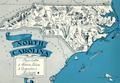 | Details | Johst, Paul Spener | 1931 |
| North Carolina Pictorial Map |
|
Johst, Paul Spener |
|
| 1931 |
| LOC:0 |
| $0.00 | Johst--Paul-Spener | North-Carolina-Pictorial-Map | SOLD
<br><br>
Pictorial map of the State of North Carolina in a cartoon-like style. Depicts industry (textile mills, furniture) and agriculture (tobacco, peanuts, cotton, corn) for the State of North Carolina in an exaggerated, stereotyped manner.
<br></br>
A decorative legend at bottom left identifies four locations within North Carolina: Charlotte, Winston Salem, Greensboro, and Raleigh. Coastal locations of Pamlico Sound, Albemarle Sound, Cape Hatteras, Cape Lookout, and Cape Fear are identieid in small type. Page 53.
<br></br>
Verso with text extolling the virtues of North Carolina geography and natural wonders.
<br></br>
From "Picture Map Geography of the United States" by Vernon Quinn. With Picture Maps by Paul Spener Johst. Publisher: Frederick A. Stokes Company. New York. 1931. Some picture maps in the book contain depictions that today might be considered politically incorrect or even racist. |
| 6551 | 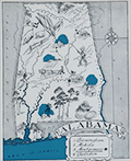 | Details | Johst, Paul Spener | 1931 |
| Johst pictorial maps of Alabama and Georgia |
|
Johst, Paul Spener |
|
| 1931 |
| LOC: |
| $135.00 | Johst--Paul-Spener | Johst-pictorial-maps-of-Alabama-and-Georgia | SOLD
<br><br>
Two pictorial maps of the states of Alabama and of Georgia in a pictorial cartoon-like style.
<br><br>
From "Picture Map Geography of the United States" by Vernon Quinn. With Picture Maps by Paul Spener Johst. Publisher: Frederick A. Stokes Company. New York. 1931. Some picture maps in the book contain depictions that today might be considered politically incorrect or even racist. |
| 1420 | 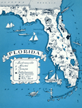 | Details | Johst, Paul Spener | 1931 |
| Florida Pictorial Map |
|
Johst, Paul Spener |
|
| 1931 |
| LOC:0 |
| $0.00 | Johst--Paul-Spener | Florida-Pictorial-Map | SOLD
<br></br>
Pictorial map of the State of Florida in a cartoon-like style. Depicts transportation (dog sledding) , nature palm trees, alligators, turtles) and recreations (auto racing, sailing) for the State of Florida in an exaggerated, stereotyped manner. The Florida keys are signified by door keys. A decorative legend identifies six locations within Florida: Jacksonville, Miami, Tallahassee, St. Augustine, Key West, and Palm Beach. Page 65.
<br></br>
Verso with text extolling the virtues of Florida's resorts and natural wonders, its swamps, and its 30,000 lakes.
<br></br>
From "Picture Map Geography of the United States" by Vernon Quinn. With Picture Maps by Paul Spener Johst. Publisher: Frederick A. Stokes Company. New York. 1931. Some picture maps in the book contain depictions that today might be considered politically incorrect or even racist. |
| 1421 | 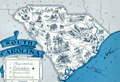 | Details | Johst, Paul Spener | 1931 |
| South Carolina Pictorial Map |
|
Johst, Paul Spener |
|
| 1931 |
| LOC:41 |
| $85.00 | Johst--Paul-Spener | South-Carolina-Pictorial-Map | Pictorial map of the State of South Carolina in a cartoon-like style. Depicts transportation (mules), agriculture (tobacco, rice, watermelon, cotton, corn) for the State of South Carolina in an exaggerated, stereotyped manner. A decorative legend at bottom left identifies four locations within South Carolina: Charleston, Columbia, Greenville, and Spartanburg. Page 57.
<br></br>
Verso with text extolling the virtues of South Carolina geography and natural wonders.
<br></br>
From "Picture Map Geography of the United States" by Vernon Quinn. With Picture Maps by Paul Spener Johst. Publisher: Frederick A. Stokes Company. New York. 1931. Some picture maps in the book contain depictions that today might be considered politically incorrect or even racist. |
| 1418 | 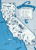 | Details | Johst, Paul Spener | 1931 |
| California Pictorial Map |
|
Johst, Paul Spener |
|
| 1931 |
| LOC:20 |
| $85.00 | Johst--Paul-Spener | California-Pictorial-Map | Pictorial map of the State of California in a cartoon-like style. Depicts transportation, chief industries (film-making, asparagus farming), nature, and recreations for the state in an exaggerated, stereotyped manner. Legend identifies 5 locations within California: Yosemite National Park, San Francissco, Oakland, Los Angeles, and San Diego. Catalina Island is identified by name. Page 181.
<br></br>
Verso with text extolling the virtues of California's natural wonders and its agriculture.
<br></br>
From "Picture Map Geography of the United States" by Vernon Quinn. With Picture Maps by Paul Spener Johst. Publisher: Frederick A. Stokes Company. New York. 1931. Some picture maps in the book contain depictions that today might be considered politically incorrect or even racist. |
| 1419 | 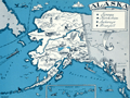 | Details | Johst, Paul Spener | 1931 |
| Alaska Pictorial Map |
|
Johst, Paul Spener |
|
| 1931 |
| LOC:41 |
| $85.00 | Johst--Paul-Spener | Alaska-Pictorial-Map | Pictorial map of the State of Alaska in a cartoon-like style. Depicts transportation (dog sledding) , nature (bears and igloos) and recreations for Alaska in an exaggerated, stereotyped manner. Legend identifies four locations within Alaska: Juneau, Ketchikan, Anchorage, and Wrangell. Kodiak Island, British Columbia and the Yukon are identified by name. Page 193.
<br></br>
Verso with text extolling the virtues of Alaska's natural wonders and its mountains; and bears.
<br></br>
From "Picture Map Geography of the United States" by Vernon Quinn. With Picture Maps by Paul Spener Johst. Publisher: Frederick A. Stokes Company. New York. 1931. Some picture maps in the book contain depictions that today might be considered politically incorrect or even racist. |