| | Thumbnail | | Creator | Date | Title / Author / Date / Location | Price | | | Description |
| 5346 | 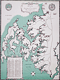 | Details | Kellogg, Charles W. | 1960 |
| Pictorial Map of Seats on Talbot County Waterways |
|
Kellogg, Charles W. |
|
| 1960 |
| LOC:53 |
| $480.00 | Kellogg--Charles-W- | Pictorial-Map-of-Seats-on-Talbot-County-Waterways | Scarce pictorial thematic map with more than 80 historic estates (seats) near Chesapeake Bay in Talbot County, Maryland. Each estate is numbered and keyed to a list with the names of their owners. Small elevation drawings of each estate provide a rough idea of how the estate looked in 1960. The map includes some old historic points of interest in Talbot County such as the old Wye Church and Friends Meeting House.
<br></br>
The large waterways shown on this estate map include the Wye River, Miles River, Harris Creek, Broad Creek, Tred Avon River, and Choptank River. Smaller waterways include among others, Goldsborough Creek, Leeds Creek, Island Creek, and Trappe's Creek. Towns in Talbot County include St. Michaels, Easton, Oxford, Queen Anne, and Trappe.
<br></br>
Map Title: "Seats on Talbot County Waterways Chesapeake Bay." By Charles W. Kellogg. Updated edition from 1960 of a map that Kellogg first published in 1949. Charles Kellogg's own estate on Skipton Creek, numbered as #1 was "Langshaws".
<br></br>
Several of the seats listed in Talbot County in 1960 are found today in the National Register of Historic Places.
<div class="indenttextblocksingle">
<ul style="list-style-type: circle;">
<li>The Anchorage: Easton. Robert L. Kemp</li>
<li>Compton: Trappe. Charles F.C. Arensberg</li>
<li>Otwell: Oxford. J. E. Jackson</li>
<li>Troth's Fortune: Easton. Frederick S. Thomas</li>
<li>Wye House. Easton. Morgan B. Schiller</li>
</ul>
</div> |