| | Thumbnail | | Creator | Date | Title / Author / Date / Location | Price | | | Description |
| 888 | 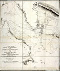 | Details | Knight, John | 1799 |
| Antique nautical chart of the coast of Hampshire, England from Portsmouth to Southampton Water |
|
Knight, John |
|
| 1799 |
| LOC:0 |
| $0.00 | Knight--John | Antique-nautical-chart-of-the-coast-of-Hampshire--England-from-Portsmouth-to-Southampton-Water | SOLD<br></br>
Antique folding sea chart of the Coast of Hampshire, England from Portsmouth to Southampton. With the northwest portion of the Isle of Wight and <b>Portsmouth Harbor</b>. Coverage includes the noted features of Calshot Castle, Gosport, Fareham, Porchester Castle, Hilsea Barracks, Langston Harbor, Portsea Island, <b>Spithead</b>, South Sea Castle, Cumberland Fort. Fort Monckton, Culver Cliffs, and Stokes Bay. Numerous sand banks are identified including Dean Sand, Horse Sand, Spit Bank, Bembridge Ledge, Mother Bank, and Bramble. With numerous soundings, buoys, anchorages and bearing lines.
<br></br>
Based on the surveys of <b>Captain John Knight, R.N.</b> (1747 - 1831) and published by William Faden from London in 1799. In 1815, after ten years commanding the garrison on Gibraltar, Captain Knight retired a full admiral to Woodend House in Soberton, Hampshire about 10 miles north of the area covered by this chart.
<br></br>
Dissected into nine segments and laid to linen with light blue satin selvage. London. Published by W Faden Geographer to His Majesty and to H.R.H. the Prince of Wales. Charing Cross, January 1, 1799. |