| | Thumbnail | | Creator | Date | Title / Author / Date / Location | Price | | | Description |
| 6637 | 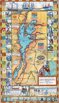 | Details | Larter, H.C. Jr. | 1939 |
| Pictorial Map of the Lake Champlain Region by Larter |
|
Larter, H.C. Jr. |
|
| 1939 |
| LOC:89 |
| $80.00 | Larter--H-C--Jr- | Pictorial-Map-of-the-Lake-Champlain-Region-by-Larter | An historical pictorial map of the Lake Champlain area surrounded on three sides by vignettes of historical events in the region. Four panels of an 8-panel brochure on Lake Champlain Bridges, specifically the Rouse's Point Bridge and the Lake Champlain Bridge. Published in 1939 by the States of New York and Vermont, Lake Champlain Bridge Commission, Crown Point, N.Y. The New York World's Fair was held in 1939 as well.
<br><br>
Verso with an eight-panel traditional driver's road map of the wider area extending from Boston at lower right to Ottawa at upper left. Printed by The National Survey, Chester, Vermont. National Survey published maps from 1912 until 2000 when they were acquired by Universal Map. |