| | Thumbnail | | Creator | Date | Title / Author / Date / Location | Price | | | Description |
| 8047 | 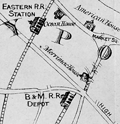 | Details | Little, N. Jr. | 1875 |
| Map of mining lands at Newbury, near Newburyport, Essex County, Massachusetts |
|
Little, N. Jr. |
|
| 1875 |
| LOC:41 |
| $950.00 | Little--N--Jr- | Map-of-mining-lands-at-Newbury--near-Newburyport--Essex-County--Massachusetts | An original late 19th century survey map titled "Map of Mining Lands at Newbury, Near Newburyport, Essex County, Massachusetts", formally entered according to Act of Congress in 1875. Issued separately in a small covered booklet. Drawn by N. Little Jr., the sheet presents a large-scale depiction of the marshlands, waterways, and adjoining uplands of the lower Merrimack and Parker River region. Not much is known about Little but several parcels of land on the map are attributed to N. Little Jr. making the author a very interested stakeholder in the maps' creation and publication.
<br><br>
Executed at a scale of 125 rods to one inch, the map delivers a level of practical detail associated with cadastral and engineering surveys rather than general town mapping. A decorative compass rose anchors the composition at left, while clearly defined town boundaries identify West Newbury, Newbury, Rowley, and Georgetown, with Newburyport situated prominently along the Merrimack River corridor.<br><br>
The map is especially informative in its integration of natural geography, transportation infrastructure, and parcel-level land division. The Merrimack River spans the upper portion of the sheet with the Newbury Flats labeled along the riverfront, while the eastern extent reaches to the Plum Island River, Plum Island, and the Atlantic Ocean, including Salisbury Beach. The Parker River winds through the lower right quadrant, fed by numerous named creeks and surrounded by finely stippled marshland drainage. Two railroad lines, the Eastern Railroad and the Boston and Maine Railroad, are clearly drawn and labeled, reinforcing the economic context of the survey. Throughout the central and southwestern areas, dense subdivision lines and owner-name annotations document individual parcels within the designated mining lands, confirming the map’s function as a legal and developmental instrument rather than a purely descriptive view of the region.<br><br> |