| | Thumbnail | | Creator | Date | Title / Author / Date / Location | Price | | | Description |
| 5440 | 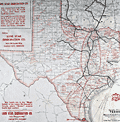 | Details | Lone Star Immigration Company | 1908 |
| Original antique advertisement map for Texas immigrants MKT |
|
Lone Star Immigration Company |
|
| 1908 |
| LOC:53 |
| $0.00 | Lone-Star-Immigration-Company | Original-antique-advertisement-map-for-Texas-immigrants-MKT | SOLD<br><br>Scarce thematic map of the state of Texas ca. 1908, an advertisement aimed at immigrants. No copy of this edition of the MK &T map of Texas is found online.
<br></br>
The map shows the lines of the Missouri, Kansas and Texas Railway as well as regional crops typically produced in each part of the state and yearly rainfall amounts. The purpose of the map was to encourage settlement in Texas, in this case to lands in the Lower Rio Grande Valley near Brownsville that were owned by the Lone Star Irrigation Company of Kansas City, Missouri.
<br></br>
The Missouri, Kansas and Texas Railway (MKT) was established in 1865. Commonly referred to as the K-T railway, the name evolved into "Katy". Following the route of an old cattle trail, the Katy became the first railroad to cross Indian Territory, now the state of Oklahoma, and enter Texas from the north. By 1904, the MKT system had over 1,110 miles of track in Texas. The railroad carried passengers and transported cattle, cotton, and other crops to market. |