| | Thumbnail | | Creator | Date | Title / Author / Date / Location | Price | | | Description |
| 902 | 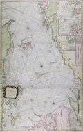 | Details | Lous, Christian Carl | 1794 |
| Chart of the Kattegat, Denmark and Sweden |
|
Lous, Christian Carl |
|
| 1794 |
| LOC:57 |
| $0.00 | Lous--Christian-Carl | Chart-of-the-Kattegat--Denmark-and-Sweden | SOLD
<br></br>
Large, bold sea chart of the Kattegat (Cattegat or Kattegatt), a shallow sea separating Denmark from Sweden. Coverage on this scarce, attractive, and colorful antique British chart includes the Jutland Peninsula, east coast of Denmark from Skagen to past Aarhus and includes the islands of Samsø or Samsoe, Læsø ("Laesso"), and Zealand with Copenhagen at the extreme bottom right. On the opposite side of the Kattegat the west coast of Sweden extends northward past Halstad, Warburg, and Gothenburg and includes the islands of Hisingen ("Hysingen") and Tjorn ("Tiorn").
<br></br>
Includes several coastal profile recognition views in the approaches to Copenhagen, Denmark. During the early 19th century the British fleet twice battled the Danes at Copenhagen, once in 1801 and again in 1807. With three inset small scale port and harbor charts including:
<ul>
<div class="indenttextblock">
<li>A Plan of Maarstrand Harbor with the Neighboring Channels </li>
<li>A Plan of the Entrances into Gothenburg.</li>
<li>The Entrances into Malo Sound within Nidingen.</li>
</div>
</ul>
This edition of the chart is based on the work of Christian Carl (or "Charles") Lous, (1724-1804) a professor and cartographer. Published by Laurie and Whittle. Fleet Street. London. 12th May, 1794. |