| | Thumbnail | | Creator | Date | Title / Author / Date / Location | Price | | | Description |
| 5022 | 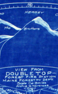 | Details | Maine Forestry Department | 1919 |
| Rare cyanotype Maine map for Double Top Fire Tower |
|
Maine Forestry Department |
|
| 1919 |
| LOC:53 |
| $0.00 | Maine-Forestry-Department | Rare-cyanotype-Maine-map-for-Double-Top-Fire-Tower | SOLD<br></br>
Rare 1919 cyanotype Maine Forest Service fire tower alidade plotting sheet: "View from Double Top Forest Fire Station Maine Forestry Department. 1919." Archie G. Norcross - Engineer. Map is 30" diameter to the outer circle. Next band- a scale from 0 to 360 degrees. Next band- shows an elevation profile matching that of the region in the far distance; flags denote other fire towers. Innermost circle- 24" diameter shows a birds eye view of the local area with the Double Top fire station located dead center in the circle.
<br></br>
From a series of circular fire tower maps commissioned by the Maine Forest Service, these circular maps display aerial and 360 degree panoramic views from many of the mountain top fire tower stations around the State of Maine. Circular map tables were oriented and fastened to the floor of the cabin of each fire tower. On each map table an alidade-type sighting device was attached which enabled the Fire Observer to more accurately pinpoint fires and record the location of a fire on the circular map laid onto the table. (https://www.aarch.org/preserve/fire-towers/)
<br></br>
One source states that the blueprint fire tower maps were used as batch master copies in the creation of multiple blue-line working maps. Of course, the inked trace diagram on tracing cloth would have been the true master copy as it was used to create each blueprint. |