| | Thumbnail | | Creator | Date | Title / Author / Date / Location | Price | | | Description |
| 1298 | 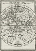 | Details | Mallet, Allain Manesson | 1683 |
| Ancien Continent or Eastern Hemisphere |
|
Mallet, Allain Manesson |
|
| 1683 |
| LOC:1 |
| $0.00 | Mallet--Allain-Manesson | Ancien-Continent-or-Eastern-Hemisphere | SOLD
<br></br>
Mallet's view of the "Ancien Continent" with its islands, oceans, seas, and gulfs. Striking and highly detailed copper engraved miniature map of the Eastern Hemisphere. A small galleon decorates the map in the "Ocean Meridionale".
<br></br>
The map shows a large unknown southern Continent. Australia is still in a conjectural form and there is a partial coastline , representing an unknown but pre-supposed land at the South Pole (later Antartica) labeled “Terres Incognues”. Mallet, drawing on geographic knowledge at his time shows an incomplete coastline for Western Australia which is not deemed important enough to even receive a label. Page 225. |
| 986 | 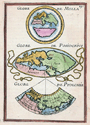 | Details | Mallet, Allain Manesson | 1683 |
| Du Globe Terrestre by Mallet |
|
Mallet, Allain Manesson |
|
| 1683 |
| LOC:0 |
| $0.00 | Mallet--Allain-Manesson | Du-Globe-Terrestre-by-Mallet | SOLD
<br></br>
Interesting illustration of 3 maps from Mallet's "Description de l'Univers" in 5 volumes of Paris, 1683. Figure LXVII . Contains three mapped representations of the known parts of the Eastern Hemisphere (Europe, Asia, and Africa) as envisioned by three cartographers: Mella, Posidonius, and Ptolemy (Ptolomee). French text on verso. |
| 1366 | 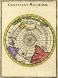 | Details | Mallet, Allain Manesson | 1683 |
| Antique Southern Polar Map of the World |
|
Mallet, Allain Manesson |
|
| 1683 |
| LOC:41 |
| $90.00 | Mallet--Allain-Manesson | Antique-Southern-Polar-Map-of-the-World | Small, hand-colored antique view of the globe from a south polar perspective. Shows the lower portions of Africa and South America. Incomplete and naïve representation of Australia, Tasmania, and New Zealand reflect that in the late 17th century knowledge of the geography of those areas was still incomplete. By Allain Mallet, Paris, 1683.
<br></br>
Published by Mallet in "Description de l'Univers" . Allain Mallet (1630-1706) was a French engineer, soldier, and cartographer. He served in the court of King Louis XIV as a teacher of mathematics. In addition to "Description de l'Univers" Mallet also published "Les Travaux de Mars ou l'Art de la Guerre". |
| 1392 | 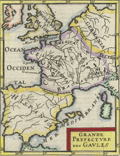 | Details | Mallet, Allain Manesson | 1683 |
| Antique map of the ancient Gaul |
|
Mallet, Allain Manesson |
|
| 1683 |
| LOC:7 |
| $120.00 | Mallet--Allain-Manesson | Antique-map-of-the-ancient-Gaul | Original antique engraved map of the ancient area controlled by the Gauls ca 1st century BC with territory identified for the Gallic tribes including Belgica, Aquitania, and Celtica. French text on verso.
<br></br>
From Mallet's "Description de l'Univers, contenant les differents systemes du Monde, les Cartes generales & particulieres de la Geographie Ancienne & Moderne . . . " By Allain Manesson Mallet. Paris, Chez Denys Thierry, Rue S. Jacques. Figure 55. Page 135. |
| 5235 | 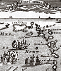 | Details | Mallet, Allain Manesson | 1683 |
| Antique Map of the Lesser Antilles or Isles Caribes |
|
Mallet, Allain Manesson |
|
| 1683 |
| LOC:5 |
| $250.00 | Mallet--Allain-Manesson | Antique-Map-of-the-Lesser-Antilles-or-Isles-Caribes | Small, fine antique map of the Lesser Antilles. Very decorative map of the islands of the Lesser Antilles from Puerto Rico all the way to the coast of Venezuela. Includes St. Martin, St. Barths, St. Kitts, Guadalupe, Trinidad, Aruba, Curacao, Bonaire and more. Depicts square-rigged sailing vessels battling at sea.
<br></br>
By A.M. Mallet in "Description de l' Univers", first published in Paris in 1683. Allain Mallet (1630-1706) was a French engineer, soldier, and cartographer. He served in the court of King Louis XIV as a teacher of mathematics. French text on the verso. |
| 5278 | 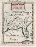 | Details | Mallet, Allain Manesson | 1683 |
| Decorative antique map of the Florida Territory |
|
Mallet, Allain Manesson |
|
| 1683 |
| LOC:11 |
| $250.00 | Mallet--Allain-Manesson | Decorative-antique-map-of-the-Florida-Territory | Unusual and somewhat primitive antique engraved map "Floride" of the eastern Gulf Coast including Florida ca. 1683. From Mallet's "Description de L'Univers". Printed from a copper-plate engraving onto chain-laid paper. Figure 18.
<br></br>
Mallet uses the names of native American Indians as place names. Florida is shown labeled as <b>Tegesta</b>. The Tegesta or Tequesta was a Native American tribe located mainly in southeastern Florida. Explorer, cartographer, and seafarer Bernard Romans used that label on his map of Florida as late as 1794.
<br></br>
Also shown is the area of the SW Florida coast inhabited by the Cossa or Calussa Indians and the area of the Apalachee Indians shown much too far to the north. |
| 918 | 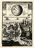 | Details | Mallet, Allain Manesson | 1683 |
| Antique print of the terrestrial globe |
|
Mallet, Allain Manesson |
|
| 1683 |
| LOC:1 |
| $55.00 | Mallet--Allain-Manesson | Antique-print-of-the-terrestrial-globe | Charming antique print of a castle with hundreds of mounted soldiers streaming out towards nearby ships. Set into that background is a view of the globe including the North and South American continents with Europe and Africa. By Allain Mallet, Paris, 1683.
<br></br>
Published by Mallet in "Description de l'Univers". Allain Mallet (1630-1706) was a French engineer, soldier, and cartographer. He served in the court of King Louis XIV as a techer of mathematics. In addition to "Description de l'Univers" Mallet also published "Les Travaux de Mars ou l'Art de la Guerre". |
| 914 | 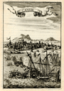 | Details | Mallet, Allain Manesson | 1683 |
| Candie |
|
Mallet, Allain Manesson |
|
| 1683 |
| LOC:2 |
| $85.00 | Mallet--Allain-Manesson | Candie | Small, attractive antique view of the harbor of Candia (Heraklion or Iraklio) on Crete, Greece with mosques and other buildings surmounted by the cresent moon of the Ottoman Caliphate. Galleys and other warships battle offshore in the Mediterranean Sea and the smoke of cannon fire indicate a westerly breeze. By Allain Mallet, Paris, 1683.
<br></br>
The Ottomans captured most of Crete during the early years of the Cretan War (1645-1669) but the Venetians retained control of the capital, Candia, until the very end in 1669. This engraved view probably captures a moment in the final battle for control of Heraklion. Page 203.
<br></br>
Published by Mallet in "Description de l'Univers" . Allain Mallet (1630-1706) was a French engineer, soldier, and cartographer. He served in the court of King Louis XIV as a techer of mathematics. In addition to "Description de l'Univers" Mallet also published "Les Travaux de Mars ou l'Art de la Guerre". |
| 917 | 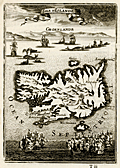 | Details | Mallet, Allain Manesson | 1683 |
| Antique map of Iceland with Greenland |
|
Mallet, Allain Manesson |
|
| 1683 |
| LOC:0 |
| $0.00 | Mallet--Allain-Manesson | Antique-map-of-Iceland-with-Greenland | SOLD
<br><br/>
Charming antique map of Iceland (Islande) with a profile view of Greenland (Groenland) in the background. Between the two islands is a scene of several whaling vessels hunting and harpooning very large whales from whaleboats. By Allain Mallet, Paris, 1683.
<br></br>
Towns depicted include Reykjavík ("Rikiaves"), Holar ("Hola"), Kopavogur ("Koplavnik"), and "Bestede". Mount Hekla ("Mont Hecla") is shown erupting vigorously and numeous other vocanic cones are depicted in the interior. A recorded eruption of Mount Hekla that began in May 1636 lasted over one year.
<br></br>
Published by Mallet in "Description de l'Univers" . Allain Mallet (1630-1706) was a French engineer, soldier, and cartographer. He served in the court of King Louis XIV as a techer of mathematics. In addition to "Description de l'Univers" Mallet also published "Les Travaux de Mars ou l'Art de la Guerre". |
| 988 | 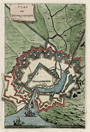 | Details | Mallet, Allain Manesson | 1684 |
| Plan of Dunkirk, France by Mallet |
|
Mallet, Allain Manesson |
|
| 1684 |
| LOC:7 |
| $60.00 | Mallet--Allain-Manesson | Plan-of-Dunkirk--France-by-Mallet | Small antique hand-colored plan of Dunkirk / Dunkerque, France. The plan shows the town with moats and surrounded by at least three walls. At the port Mallet shows several ships entering from offshore.
<br></br>
From "Les Travaux de Mars ou l'Art de la Guerre " in 3 volumes. Paris, 1684. Figure LXVII . French text on verso. Page 213. |
| 1424 | 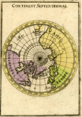 | Details | Mallet, Allain Manesson | 1685 |
| Antique Northern Hemisphere Polar Map |
|
Mallet, Allain Manesson |
|
| 1685 |
| LOC:41 |
| $90.00 | Mallet--Allain-Manesson | Antique-Northern-Hemisphere-Polar-Map | Small, hand-colored antique view of the northern hemisphere from a north polar perspective. Shows the so-called "Arctic Lands" with Greenland connected to northern Canada. Shows Iceland, Spitsbergen, and the "Terre de Iesso" or the Japanese island of Hokkaido . Fig 16.
<br></br>
By Allain Mallet, Paris, 1683 in a German edition of "Description de l'Univers" . Allain Mallet (1630-1706) was a French engineer, soldier, and cartographer. He served in the court of King Louis XIV as a techer of mathematics. In addition to "Description de l'Univers" Mallet also published "Les Travaux de Mars ou l'Art de la Guerre". |
| 3660 | 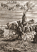 | Details | Mallet, Allain Manesson | 1719 |
| Neat antique view of Iceland |
|
Mallet, Allain Manesson |
|
| 1719 |
| LOC:77 |
| $175.00 | Mallet--Allain-Manesson | Neat-antique-view-of-Iceland | Manneson-Mallet's small and very interesting view of Hecla a volcano on Iceland, a Nordic island country in the North Atlantic Ocean. Hekla (Hecla) is a large and active volcano on the south of Iceland, part of a 40 mile long volcanic ridge. |