| | Thumbnail | | Creator | Date | Title / Author / Date / Location | Price | | | Description |
| 1220 | 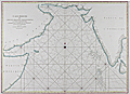 | Details | Mannevillette, d'Apres | 1775 |
| Antique Chart of the Arabian Sea, Gulf of Aden, and Gulf of Oman |
|
Mannevillette, d'Apres |
|
| 1775 |
| LOC:59 |
| $925.00 | Mannevillette--d-Apres | Antique-Chart-of-the-Arabian-Sea--Gulf-of-Aden--and-Gulf-of-Oman | Large striking antique sea chart centered on the Arabian Sea. This copperplate navigational chart was printed in Paris ca. 1775 based on the explorations of d'Apres de Mannvillette. Includes the Laccadive Archipelago, Sri Lanka ( Ceylan ), the Maldive Archipelago, the Gulf of Aden and Gulf of Oman. Key cities noted include Aden, Oman, Muscat, Mumbai ( Bombay ), Surate, Goa, Pondicherry, and Colombo. Simple outline hand-coloring and the absence of interior details lends this fine example a striking graphical appearance. |
| 1206 | 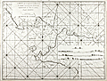 | Details | Mannevillette, d'Apres | 1775 |
| Chart of the Sunda Strait between Sumatra and Java |
|
Mannevillette, d'Apres |
|
| 1775 |
| LOC:59 |
| $0.00 | Mannevillette--d-Apres | Chart-of-the-Sunda-Strait-between-Sumatra-and-Java | SOLD
<br></br>
Fine original 18th century French nautical chart of the Sunda Strait ("Detroit de la Sonde") with Jakarta, Indonesia (Batavia) at extreme right. Very rare, no record of any sale of this chart is found in the AMPR, nor is any holding found online.
<br></br>
The Sunda Strait is a narrow waterway connecting the Java Sea to the Indian Ocean. Includes the Indonesian islands of Sumatra and Java. With four attractive inset elevation views of Sunda Strait and coast as seen from offshore. Numerous depth soundings and place names are provided. Engraved by Dheulland.
<br></br>
From J. B. d'Apres de Mannevillette's sea atlas "Le Neptune Oriental ou routier general des Cotes des Indes orientales et de la Chine." Jean-Baptiste d'Après de Mannevillette (1707 - 1780) was a French sailor, navigator, and hydrographer active in the mid-18th century. Mannevillette studied mathematics and navigation in Paris before winning a commission as an officer on a merchant vessel headed for the West Indies. Mannevillette collected and revised a number of regional nautical charts during numerous voyages around Africa to India and China.
<br></br>
Antique copper-engraving, published in Paris, ca. 1775. No folds. |
| 1207 | 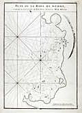 | Details | Mannevillette, d'Apres | 1775 |
| Early chart of Jeddah, Saudi Arabia |
|
Mannevillette, d'Apres |
|
| 1775 |
| LOC:0 |
| $0.00 | Mannevillette--d-Apres | Early-chart-of-Jeddah--Saudi-Arabia | <b>SOLD</b>, but see <a href="https://www.rarecharts.com/ShowDetail/Creator/Mannevillette--d-Apres/Title/Antique-chart-of-Jeddah-Gedda-Saudi-Arabia/4828" target="_blank">another example</a> now in stock.
<br></br>
Early French nautical chart of the anchorage of Jeddah, Saudi Arabia on the Red Sea. Shows the passage into the port of "Gedda" with a defensive wall. Curved elevation view of the coastline near Jeddah, Saudi Arabia. |
| 5207 | 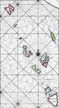 | Details | Mannevillette, d'Apres | 1775 |
| Nautical chart of the Nicobar Islands Indian Ocean |
|
Mannevillette, d'Apres |
|
| 1775 |
| LOC:9 |
| $300.00 | Mannevillette--d-Apres | Nautical-chart-of-the-Nicobar-Islands-Indian-Ocean | Original engraved sea chart of the Nicobar Island Archipelago in the Bay of Bengal. Islands in the Nicobar Archipelago include Car Nicobar, Battimalym, Chowra, Great Nicobar, Little Nicobar, Katchal, Nancowry, and more. In 2013 UNESCO declared 85% of Great Nicobar Island, the largest, as the Great Nicobar Biosphere Reserve.
<br></br>
Manvillette's chart Includes an inset plan of the channel between the islands of Camorta, Nancowry, and Trincut which would have provided a harbor from storms but where navigation without the chart would have been dangerous: "Plan Particulier du Port Compris entre les Isles Nancaueri, Souri, et Tricutte."
<br></br>
This fine hand-colored nautical chart is from J. B. d'Apres de Mannevillette's sea atlas "Le Neptune Oriental ou routier general des Cotes des Indes orientales et de la Chine." Jean-Baptiste d'Après de Mannevillette (1707 - 1780) was a French sailor, navigator, and hydrographer active in the mid-18th century. Mannevillette studied mathematics and navigation in Paris before winning a commission as an officer on a merchant vessel headed for the West Indies. Mannevillette collected and revised a number of regional nautical charts during numerous voyages around Africa to India and China. |
| 7887 | 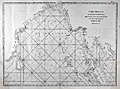 | Details | Mannevillette, d'Apres | 1775 |
| Malacca Strait Bay of Bengal, from the Isle of Ceylon Gulf of Siam |
|
Mannevillette, d'Apres |
|
| 1775 |
| LOC:141 |
| $495.00 | Mannevillette--d-Apres | Malacca-Strait-Bay-of-Bengal--from-the-Isle-of-Ceylon-Gulf-of-Siam | A fine 18th-century nautical chart of the Bay of Bengal ."Carte Reduite du Golfe de Bengale, depuis L'Isle De Ceylan jusqu'au Golfe De Siam, avec la partie Septentrionale du Detroit De Malac". Produced by Jean-Baptiste Nicolas Denis d'Après de Mannevillette (1707-1780).
<br><br>
It depicts the Bay of Bengal region, extending from Ceylon (present-day Sri Lanka) to the Gulf of Siam (now known as the Gulf of Thailand), and include the northern part of the Strait of Malacca.
<br><br>
<div style="text-align: center;font-size:105%;">
<i>Professional hand coloring for this chart is available at a very modest fee.</i>
</div> |
| 6704 | 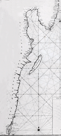 | Details | Mannevillette, d'Apres | 1775 |
| Chart of the east coast of Madagascar |
|
Mannevillette, d'Apres |
|
| 1775 |
| LOC:68 |
| $475.00 | Mannevillette--d-Apres | Chart-of-the-east-coast-of-Madagascar | Original French nautical chart of a portion of the east coast of the island of Madagascar, off the east coast of Africa. From the second edition of Le Neptune Oriental published 1775 in Paris.
<br><br>
The most prominent feature of the chart is Antongil Bay, a large bay located on the northeast coast of Madagascar. The bay is known for its beautiful beaches, rich biodiversity, and important fishing industry. The surrounding area is also home to several protected areas, including the Masoala National Park and the Nosy Mangabe Special Reserve.
<br><br>
Antongil Bay has a rich history dating back to the early days of Madagascar's settlement by humans. The bay was a major center of trade and commerce for the island's indigenous populations, who used it to transport goods and communicate with other communities along the coast.
<br><br>
During the colonial period, Antongil Bay became an important center of trade for the French, who established several ports along its shores. The bay was used to transport goods such as vanilla, cloves, and other spices, which were grown on plantations throughout the region
<br><br>
The chart includes large-scale inset plans for the following bays and anchorages:
<div class="indenttextblocksingle">
<ul style="list-style-type: circle;"></li>
<li>Plan de l'Ance de Tamatave</li>
<li>Plan de l'Anse de Veninguebe</li>
<li>Plan du Port de Teintingue</li>
<li>Plan de la Rade de Fullpointe</li>
</ul>
</div> |
| 6491 | 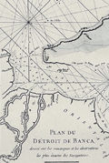 | Details | Mannevillette, d'Apres | 1775 |
| Antique nautical chart of the Bangka or Banca Strait |
|
Mannevillette, d'Apres |
|
| 1775 |
| LOC:90 |
| $250.00 | Mannevillette--d-Apres | Antique-nautical-chart-of-the-Bangka-or-Banca-Strait | Antique nautical chart of the Detroit du Banca or Bangka Strait from 1775 by Jean-Baptiste-Nicolas-Denis D’ Après de Mannevillette (1707 – 1780). Inset chart of a smaller strait between the Isle de Sel and part of Biliton Island or Belitung Island. That strait lies approximately 70 miles to the east of south Bangka Island.
<br><br>
The map is particularly interesting historically as it incorporates paste-over corrections to the eastern portion of the Isle de Banca with the previously charted coastline still faintly visible beneath the corrections. According to a pasted note at bottom left, the pasted corrections to the northeast of Bangka Island were based on the observations of M. Crozet. Julien Crozet was second in command during the French expedition of Marion De Fresne to Tasmania, New Zealand, and the South Pacific, sailing in 1771. Crozet assumed command of the expedition after the voyage's commander, Marion De Fresne, and 26 crew members were killed by the Maori Ngare Raumati tribe off the coast of New Zealand in June 1772.
<br><br>
Bangka Strait is the narrow body of water that separates the island of Sumatra from the Indonesian island of Bangka. Bangka is one of the world's most important tin-producing areas. |
| 798 |  | Details | Mannevillette, d'Apres | 1775 |
| Antique chart of the Strait of Bali with Madura and Java |
|
Mannevillette, d'Apres |
|
| 1775 |
| LOC:9 |
| $550.00 | Mannevillette--d-Apres | Antique-chart-of-the-Strait-of-Bali-with-Madura-and-Java | Antique French nautical chart of the Bali Strait with Java to the left and Bali at right and the Island of Madura at top. This attractive 1775 sea chart contains an inset plan of Banyuwangi Bay ("Baye de Ballambouang") and three inset profile coastal views of the headlands surrounding the Bali Strait.
<br></br>
Key points of interest include Buleleng ("Bollilingh"), Bali; the Madura Strait; Sumenep, Madura; Palau Puteran; Palau Gili Iyang; Palau Sapudi ("Isle Galioen ou Respondi"); Palau Raas ("Isle de Entrepot").
<br></br>
The chart is based on exploration and observations aboard several vessels: France's "Elephant", and several British ships including the 29 gun East Indiaman "Winchelsea" commanded by Thomas Howe. Number 45.
<br></br>
By Jean-Baptiste d'Après de Mannevillette (1707 - 1780) a French sailor, navigator, and hydrographer active in the mid-18th century. Mannevillette studied mathematics and navigation in Paris before winning a commission as an officer on the merchant headed for the West Indies. Mannevillette collected and revised a number of regional nautical charts during numerous voyages around Africa to India and China. |
| 5306 | 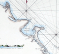 | Details | Mannevillette, d'Apres | 1775 |
| Rare French charts of Vietnam Coast including Da Nang |
|
Mannevillette, d'Apres |
|
| 1775 |
| LOC:9 |
| $475.00 | Mannevillette--d-Apres | Rare-French-charts-of-Vietnam-Coast-including-Da-Nang | Two original antique engraved charts on a single sheet: the Con Son Island Archipelago and Da Nang Bay including the Vietnam coast between the towns of Hue and Da Nang: "Plan de l'Isle Condor"; "Carte d'une Partie de la Cote de Cochinchine".
<br></br>
Includes three fine inset coastal elevation views:
<div class="indenttextblocksingle">
<ul style="list-style-type: circle;">
<li>Vue de l'Isle Champello ou Cham Collao.</li>
<li>Vue de l'entrée de la Baye de Touranne (Da Nang was known as Tourane during the French colonial period)</li>
<li>Vue de l'Isle Condor lorsque la Havre...</li>
</ul>
</div>
From J. B. d'Apres de Mannevillette's sea atlas "Le Neptune Oriental ou routier general des Cotes des Indes orientales et de la Chine." Jean-Baptiste d'Après de Mannevillette (1707 - 1780) was a French sailor, navigator, and hydrographer active in the mid-18th century. Mannevillette studied mathematics and navigation in Paris before winning a commission as an officer on a merchant vessel headed for the West Indies. Mannevillette collected and revised a number of regional nautical charts during numerous voyages around Africa to India and China.
The Compagnie des Indes (French East India Company) appointed D'Apres de Mannevillette as director of maps and plans at Lorient in 1752. |
| 4828 | 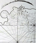 | Details | Mannevillette, d'Apres | 1775 |
| Antique chart of Jeddah Gedda Saudi Arabia |
|
Mannevillette, d'Apres |
|
| 1775 |
| LOC:88 |
| $900.00 | Mannevillette--d-Apres | Antique-chart-of-Jeddah-Gedda-Saudi-Arabia | Rare. Early French nautical chart of the anchorage of Jeddah, Saudi Arabia on the Red Sea. Shows the passage into the port of "Gedda" with a defensive wall. Curved elevation view of the coastline near Jeddah, Saudi Arabia.
<br></br>
From J. B. d'Apres de Mannevillette's sea atlas "Le Neptune Oriental ou routier general des Cotes des Indes orientales et de la Chine." Jean-Baptiste d'Après de Mannevillette (1707 - 1780) was a French sailor, navigator, and hydrographer active in the mid-18th century. Mannevillette studied mathematics and navigation in Paris before winning a commission as an officer on a merchant vessel headed for the West Indies. Mannevillette collected and revised a number of regional nautical charts during numerous voyages around Africa to India and China.
<br></br>
Antique copper-engraving, published in Paris, ca. 1775. No folds. (Jiddah) |
| 44 | 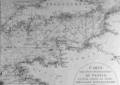 | Details | Mannevillette, d'Apres | 1780 |
| Carte des Cotes Occidentales de France |
|
Mannevillette, d'Apres |
|
| 1780 |
| LOC:0 |
| $0.00 | Mannevillette--d-Apres | Carte-des-Cotes-Occidentales-de-France | SOLD<BR> </BR>
Two-page black and white antique nautical chart of west France, northern Spain, southern Britain, and Ireland on chain-laid paper. Illegible watermark. Primary focus is coverage of the Gulf of Gascogne and the approaches to the English Channel. Small central compass rose with numerous rhumb lines. North at top of chart. Plate I. |