| | Thumbnail | | Creator | Date | Title / Author / Date / Location | Price | | | Description |
| 6545 | 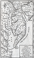 | Details | Mason, Charles and Jeremiah Dixon | 1769 |
| Scarce Chesapeake region map from the survey of Mason and Dixon |
|
Mason, Charles and Jeremiah Dixon |
|
| 1769 |
| LOC:78 |
| $400.00 | Mason--Charles-and-Jeremiah-Dixon | Scarce-Chesapeake-region-map-from-the-survey-of-Mason-and-Dixon | Scarce map of the Chesapeake Bay region with portions of Maryland, Virginia, Delaware, New Jersey and Pennsylvania. The map shows the results of Charles Mason and Jeremiah Dixon's survey of the boundary between the states of Pennsylvania and Maryland. Published in Gentleman's Magazine, 1769.
<br><br>
Surveyors Charles Mason and Jeremiah Dixon spent 58 months establishing the boundaries of Pennsylvania, Maryland, Delaware and West Virginia. The team attained widespread recognition as the creators of the Mason-Dixon Line, the de facto border between the northern and southern United States. Key features include: the Potowmack River, Cape May, Cape Charles, Baltimore, Philadelphia, and Annapolis. Shows several of the key roads in use during the mid 18th-century. |