| | Thumbnail | | Creator | Date | Title / Author / Date / Location | Price | | | Description |
| 2494 | 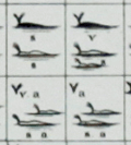 | Details | Maury, Matthew Fontaine | 1956 |
| Maury's Whale Chart 3rd. Ed |
|
Maury, Matthew Fontaine |
|
| 1956 |
| LOC:0 |
| $0.00 | Maury--Matthew-Fontaine | Maury-s-Whale-Chart-3rd--Ed | SOLD
<br></br>
Rare thematic chart of reported whale sightings by geographic area, whale species, and relative number of sightings.
<br></br>
Third issue (of four). Hydrographic Office of the US in the mid 20th century. Upper top left position with logo of eagle clutching items in claws surrounded by text: "Hydrographic Office U.S. Navy". Top right position is blank. Bottom right position reads "Price 20 cents / H.O. Miscel. No. 8514" Mid-20th-century electrotype on wove paper. This instance of Maury's whale chart carries a blue ink over-stamp from the U.S. Naval Supply Depot at Scotia, NY. "Corrected through Notice to Mariners No. 25 June 23, '56" that is- 1956. |
| 6811 | 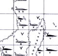 | Details | Maury, Matthew Fontaine | 1956 |
| Matthew Maury's Whale Chart Third Ed |
|
Maury, Matthew Fontaine |
|
| 1956 |
| LOC:68 |
| $1,900.00 | Maury--Matthew-Fontaine | Matthew-Maury-s-Whale-Chart-Third-Ed | Rare world-wide thematic chart of reported whale sightings by Matthew Fontaine Maury. Provides data on whale sightings by season, geographic area, whale species, and relative frequency. First published in 1851 but this 3rd edition re-issued in 1956 by the U. S. Navy Hydrographic Office.
<br><br>
Maury's Whale Chart provided valuable information about the migratory patterns of various whale species based on data collected from whalers and merchant ships and depicted the seasonal movements of different whale species in the Atlantic and Pacific Oceans. It included information about the regions where whales were most commonly found during specific times of the year, helping whalers optimize their efforts and increase their chances of successful hunts.
<br><br>
The last three editions of Maury's Whale Chart may be identified thus:
<div class="indenttextblocksingle">
<ul style="list-style-type: circle;">
<li><b>Third Edition (1956)</b></br>
Upper top left position with logo of eagle clutching items in claws surrounded by text: "Hydrographic Office U.S. Navy". Top right position is blank. Bottom right position reads "Price 20 cents / H.O. Miscel. No. 8514".</li>
<li><b>Fourth edition (1960)</b></br>
Upper top left position with logo of eagle over an anchor surrounded by text: "United States Hydrographical Office". Top right position reads "Catalog: Introduction. Part 1.". Bottom right position reads "Price 50 cents / H.O. Miscel. No. 8514" .
</li>
<li><b>Fifth edition (after 1972)</b></br>
Upper top left with logo containing an eagle perched on a globe with text "Defense Mapping Agency". Top right position reads "Catalog P2V10". Bottom right reads "Lith of Wm. Endicott & Co. N. York | 5018 | DMA Stock Number | W0XZC5018.</li>
</ul>
</div> |
| 4935 | 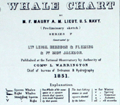 | Details | Maury, Matthew Fontaine | 1960 |
| Maury's Whale Chart 4th Edition |
|
Maury, Matthew Fontaine |
|
| 1960 |
| LOC:0 |
| $0.00 | Maury--Matthew-Fontaine | Maury-s-Whale-Chart-4th-Edition | SOLD
<br></br>
Rare thematic chart of reported whale sightings by geographic area, whale species, and relative number of sightings. An early example of the graphical display of quantitative information for decision making.
<br></br>
Matthew Maury's Whale Chart, was first issued by the United States Bureau of Ordnance & Hydrography in 1851. This is the fourth (4th.) edition, from the United State Hydrographical Office in the 1960s.
<br/></br/>
Upper top left position with logo of eagle over an anchor surrounded by text: "United States Hydrographical Office". Top right position reads "Catalog: Introduction. Part 1.". Bottom right position reads "Price 50 cents / H.O. Miscel. No. 8514" Mid-20th-century electrotype on wove paper. This instance of Maury's whale chart carries two unknown blue ink accession hand stamps in the far bottom right margin: "June 23, 1969." and "Accession no. [in MS] 763."
<br></br>
Shows best whaling areas and migration patterns for sperm whales and right whales, as well as the most densely populated areas and areas of "Straggling" Sperm Whales and Right Whales. |
| 5420 | 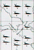 | Details | Maury, Matthew Fontaine | 1972 |
| Maurys Whale Chart 5th Edition |
|
Maury, Matthew Fontaine |
|
| 1972 |
| LOC:0 |
| $1,500.00 | Maury--Matthew-Fontaine | Maurys-Whale-Chart-5th-Edition | Scarce official U.S. thematic chart of reported whale sightings by geographic area, whale species, and relative number of sightings (5th ed. ca. 1972). An early example of the graphical display of quantitative information for decision making. The chart shows the best whaling areas and migration patterns for sperm whales and right whales, as well as the most densely populated areas of "Straggling" Sperm Whales and Right Whales." Chart # 5018.
<br></br>
Matthew Maury's Whale Chart, was first issued by the United States Bureau of Ordnance & Hydrography in 1851. This is the official U.S. fifth (5th.) edition, from the United States Defense Mapping Agency Hydrographic/Topographic Center in the 1970s. The DMA existed from 1972 through 1996. The first edition of Maury's Whale Chart is extremely rare on the market. Only one sale of Maury's chart is recorded in the Antique Map Price Record.
<br/></br/>
The last three editions of Maury's Whale Chart may be identified thus:
<div class="indenttextblocksingle">
<ul style="list-style-type: circle;">
<li><b>Third Edition (1956)</b></br>
Upper top left position with logo of eagle clutching items in claws surrounded by text: "Hydrographic Office U.S. Navy". Top right position is blank. Bottom right position reads "Price 20 cents / H.O. Miscel. No. 8514".</li>
<li><b>Fourth edition (1960)</b></br>
Upper top left position with logo of eagle over an anchor surrounded by text: "United States Hydrographical Office". Top right position reads "Catalog: Introduction. Part 1.". Bottom right position reads "Price 50 cents / H.O. Miscel. No. 8514" .
</li>
<li><b>Fifth edition (after 1972)</b></br>
Upper top left with logo containing an eagle perched on a globe with text "Defense Mapping Agency". Top right position reads "Catalog P2V10". Bottom right reads "Lith of Wm. Endicott & Co. N. York | 5018 | DMA Stock Number | W0XZC5018.</li>
</ul>
</div> |