| | Thumbnail | | Creator | Date | Title / Author / Date / Location | Price | | | Description |
| 8006 | 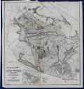 | Details | McClintock, John N. | 1892 |
| 1st Edition Topo Survey Map of Lynn Woods Massachusetts |
|
McClintock, John N. |
|
| 1892 |
| LOC: |
| $0.00 | McClintock--John-N- | 1st-Edition-Topo-Survey-Map-of-Lynn-Woods-Massachusetts | SOLD<br><br>Rare first-edition topographical survey of Lynn Woods, produced in 1892 when the reservation was first mapped with scientific accuracy. McClintock's survey is the earliest to depict the entire Lynn Woods area with true contour intervals (set here at 10 feet), replacing the hachured and sketch-based plans of the previous decades. The sheet documents carriage roads, footpaths, ponds, hills, and the internal structure of the reservation with the accuracy suited to modern municipal water-supply and forest management at a moment just before creation of the Metropolitan Park Commission.
<br><br>
This map reflects the conservation principles advanced by landscape architect Charles Eliot, who emphasized that sound public decisions must rest on accurate knowledge of the land. As he stated, "We must first know the character of the land if we are to judge wisely concerning its future use." Eliot also pointed to Lynn Woods as an early example of successful municipal action, observing that "Lynn has taken steps which other towns would do well to study." The survey represents that period in regional planning when detailed documentation of terrain, water, and forest formed the basis for long-term preservation efforts.<br><br>Two editions of McClintock's map exist: this original 1892 survey and a second 1910 revised edition updated by Charles A. Lawrence. The later edition shows added carriage roads, wood roads, and footpaths, including routes into areas previously shown as inaccessible, such as "The Island" in Tomlin's Swamp.
<br><br>
By 1910 a forester's house and an access road near Dog Hill appear, while the Belt Line Railway Station and track at the end of Park Avenue, present in 1892, are gone. These changes illustrate Lynn Woods' shift from a watershed landscape to a more formally managed public reservation.
<br><br>
The only other recorded example of this map in WorldCat is held by the Harvard Library. Inset map showing the location of Lynn Woods.<br><br> |