| | Thumbnail | | Creator | Date | Title / Author / Date / Location | Price | | | Description |
| 5163 |  | Details | Mentelle and Chanlaire | |
| Carte de la Caroline Meridionale et Septentrionale et de la Virginie |
|
Mentelle and Chanlaire |
|
|
| LOC:10 |
| $400.00 | Mentelle-and-Chanlaire | Carte-de-la-Caroline-Meridionale-et-Septentrionale-et-de-la-Virginie | Antique engraved map of the Southeast U.S.A. from Mentelle & Chanlaire's "Atlas Universel". Identifies some of the early roads in the Carolinas and Virginia, early western trade routes and settlements. Covers from the Delaware Bay to the Savannah River and inland as far as modern-day Iowa.
<br></br>
This finely engraved original map was published from Paris, France in 1795, shortly after the end of the Revolutionary war. Engraved by Tardieu |
| 1382 | 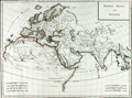 | Details | Mentelle and Chanlaire | 1798 |
| Fine antique 18th-century map with Europe and Asia |
|
Mentelle and Chanlaire |
|
| 1798 |
| LOC:9 |
| $220.00 | Mentelle-and-Chanlaire | Fine-antique-18th-century-map-with-Europe-and-Asia | Beautifully engraved and hand-colored map centered on the Arabian Peninsula with much of that area designated "Arabia Deserta". Includes Scandinavia, north Africa, India, China, Sri Lanka ("Taprobana"), and much more. The title indicates that the coverage includes those portions of the world's surface that were known to exist in antiquity. Engraved by Tardieu.
<br></br>
The curved map projection and the fine coloring work act synergistically to emphasize the curvature of the earth's surface.
<br></br>
Published from Paris by French cartographers E. Mentelle and Pierre-Giles Chanlaire. Edme Mentelle (1730 - 1816) was a French geographer and historian in Paris who studied under the historian Jean-Baptiste Louis Crevier at the College of Beauvais. After accepting a position as professor of Geology and History at the Ecole Militaire he tutored students including the young Napoleon Bonaparte. Mentelle published a number of important geographical works including the 1778 Geographie Comparee, the 1779 Atlas Universel, and the 1801 Cours Complet de Cosmographie, de Chronologie, de Geographie et d'Histoire. Plate 3. |
| 3609 | 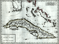 | Details | Mentelle and Chanlaire | 1798 |
| Attractive antique map of Florida, Cuba, and Bahamas |
|
Mentelle and Chanlaire |
|
| 1798 |
| LOC:0 |
| $0.00 | Mentelle-and-Chanlaire | Attractive-antique-map-of-Florida--Cuba--and-Bahamas | SOLD
<br></br>
Beautifully engraved and hand-colored map of southern Florida, Cuba, and the Bahama Islands (or Lucayes) from 1798. Points of interest in Florida include the Florida Keys (les Martyres), Port St. Lucie (Punta de Santa Lucia), Palm Beach (Cap della Floride), Cape Biscayne (Cap Biscaino). Beautifully engraved by Pierre Tardieu.
<br></br>
Published from Paris by French cartographers E. Mentelle and Pierre-Giles Chanlaire. Edme Mentelle (1730 - 1816) was a French geographer and historian in Paris who studied under the historian Jean-Baptiste Louis Crevier at the College of Beauvais. After accepting a position as professor of Geology and History at the Ecole Militaire he tutored students including the young Napoleon Bonaparte. Mentelle published a number of important geographical works including the 1778 Geographie Comparee, the 1779 Atlas Universel, and the 1801 Cours Complet de Cosmographie, de Chronologie, de Geographie et d'Histoire. Plate 3. |
| 1339 | 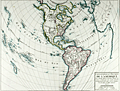 | Details | Mentelle and Chanlaire | 1798 |
| Fine antique map of the Americas |
|
Mentelle and Chanlaire |
|
| 1798 |
| LOC:0 |
| $0.00 | Mentelle-and-Chanlaire | Fine-antique-map-of-the-Americas | SOLD
<br></br>
Beautifully engraved and hand-colored map of the western hemisphere focused on North America and South America. The combination of the curved map projection and the fine coloring work act synergistically to emphasize the curvature of the earth's surface. The map projection allows the inclusion of Africa and Europe at right, and New Zealand and the Pacific Islands at left.
<br></br>
The date of "An VI" dates the map to the sixth year of the French Revolution or 1798 in the Gregorian calendar. Interesting bit of land shown north of the Arctic Circle outside the neatline.
<br></br>
Political subdivisons shown in red. Published from Paris by French cartographers E. Mentelle and Pierre-Giles Chanlaire. Number 155. |