| | Thumbnail | | Creator | Date | Title / Author / Date / Location | Price | | | Description |
| 260 | 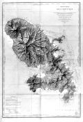 | Details | Monnier, Paul | 1893 |
| Carte Generale de la Martinique |
|
Monnier, Paul |
|
| 1893 |
| LOC:51 |
| $375.00 | Monnier--Paul | Carte-Generale-de-la-Martinique | Striking, antique sea chart / map of the island of Martinique, an overseas region of France, in the eastern Caribbean. This large chart is an 1877 edition of a chart first produced in 1831 by Monnier for France's Depot de la Marine, printed with corrections in 1893. . The chart is a fine example of the extensive use of hachuring to convey interior details of the island. <br></br>
Lighthouses dotted in yellow. Contains the circular seal for the Depot General de la Marine . |