| | Thumbnail | | Creator | Date | Title / Author / Date / Location | Price | | | Description |
| 1001 | 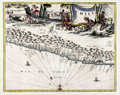 | Details | Montanus, Arnoldus | 1671 |
| Chile (Chile) South America |
|
Montanus, Arnoldus |
|
| 1671 |
| LOC:0 |
| $0.00 | Montanus--Arnoldus | Chile-(Chile)-South-America | SOLD<br></br>
Attractive map of coastal Chile ("Chili") in South America by Arnoldus Montanus, after Ogilby. From Montanus' "De Nieuwe en Onbekende Weereld: of Beschryving van America." Shows the major portion of Chile between 25 and 45 degrees south latitude. The Andes ("Sierra nevado de los Andes") are shown in profile, and most of the major bays and islands are identified by name. Key features include Arauco, Concepcion, la Mocha island, Santiago (St. Jago de la Nueva Estres madura), Rio Mapocho, la Serena, and Rio Copiapo.
<br></br>
Very decorative map with a large scene of industrious natives and cherubs. The ocean is filled with two Spanish galleons and a compass rose. |