| | Thumbnail | | Creator | Date | Title / Author / Date / Location | Price | | | Description |
| 851 | 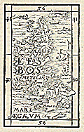 | Details | Munster, Sebastien | 1571 |
| Antique wood cut of the island of Lesbos, Greece |
|
Munster, Sebastien |
|
| 1571 |
| LOC:2 |
| $150.00 | Munster--Sebastien | Antique-wood-cut-of-the-island-of-Lesbos--Greece | Antique wood block printed map of the island of Lesbos ( Lesvos ), Greece in the northeastern Aegean Sea.
<br></br>
From "Strabonis rerum geographicarum libri septemdecim" authored by Sebastien Munster and published by Heinrich Petri. Map is inset in a 8"x11" full page of text, both in Greek and Latin. Text on verso. |
| 831 | 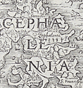 | Details | Munster, Sebastien | 1571 |
| Antique map of the island of Cephalonia, Greece |
|
Munster, Sebastien |
|
| 1571 |
| LOC:0 |
| $0.00 | Munster--Sebastien | Antique-map-of-the-island-of-Cephalonia--Greece | SOLD<br></br>Rare original 16th century wood cut map of Cephalonia ( Kefalonia ), Greece, the largest of the Ionian islands. In this decorative map from 1571 a half dozen towns are identified including Fiskardo ( "Viscardo" ), "Palis", Sami ( "Samos" ), "Cranis", and "S. Francifeus".
<br></br>
The Ionian islands are off the West coast of the Peloponnese peninsula in Southern Greece. The island of Lefkada ( "Levcas" ) is shown to the north.
<br></br>
From "Strabonis rerum geographicarum libri septemdecim" authored by Sebastien Munster and published by Heinrich Petri. Map is inset in a 8"x11"full page of text, both in Greek and Latin. Text on verso. |
| 832 | 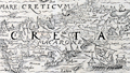 | Details | Munster, Sebastien | 1571 |
| Antique wood cut of the island of Crete, Greece |
|
Munster, Sebastien |
|
| 1571 |
| LOC:2 |
| $150.00 | Munster--Sebastien | Antique-wood-cut-of-the-island-of-Crete--Greece | Antique map of Crete ( "Creta" ), Greece in the southern Aegean Sea. In this decorative map from 1571 numerous towns are identified including Heraklion ( "Heraclea" ) , Chania ( "Candia" ), Rethymno ( "Rhithymna" ), and "Minoa". Crete was home to the Bronze age Minoan civilization. Today remains of the Minoan civilization are found across the island, particularly at the archaeological sites of Knossos, Phaistos, Malia, and Kato Zakros.
Several mountain chains and rivers are shown on this rare wood cut map of Crete. In the bottom right corner Munster has placed a large oared galley, with the Lion of St. Marks painted on its lateen sail, signifying Venice's rule over the island for more than four centuries.
<br></br>
From "Strabonis rerum geographicarum libri septemdecim" authored by Sebastien Munster and published by Heinrich Petri. Map is inset in a 8"x11"full page of text, both in Greek and Latin. Text on verso. |
| 693 |  | Details | Munster, Sebastien | 1580 |
| Antique early map of Greece with Istanbul |
|
Munster, Sebastien |
|
| 1580 |
| LOC:2 |
| $0.00 | Munster--Sebastien | Antique-early-map-of-Greece-with-Istanbul | SOLD
<br><br>
Antique woodcut map of Greece published ca. 1578 by Sebastien Munster in a French edition of his Cosmographie. At extreme upper right Munster denotes the triple-walled city of Constantinople (modern Istanbul, Turkey) astride the Bosphorus Strait. In addition to Constantinople, small iconized dwellings represent the towns of Edirne ( Adrianople ), Modon, Corinth, and Salonica. Other geographical features include: Mount Olympus, Thrace, Albania, Macedonia, and the Greek Islands of Crete, Corfu, Lemnos, Lesbos, Samos, Melos, and Negroponte.
<br></br>
Woodcut is inset into French text. Verso contains French text and a small woodcut of a 16th century nobleman. Page 1052. |