| | Thumbnail | | Creator | Date | Title / Author / Date / Location | Price | | | Description |
| 7995 | 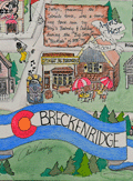 | Details | Nadon, Paul | 1985 |
| Humorous pictorial map of Breckenridge, Colorado from 1985. |
|
Nadon, Paul |
|
| 1985 |
| LOC:130 |
| $450.00 | Nadon--Paul | Humorous-pictorial-map-of-Breckenridge--Colorado-from-1985- | This colorful pictorial poster map of Breckenridge, Colorado, created and signed by Paul Nadon, presents a detailed illustrated view of the town’s commercial core and surrounding mountain setting as it was in the mid-1980's. The drawing highlights Main Street and nearby blocks through individually rendered storefronts, lodges, restaurants, ski shops, and local businesses, each shown with distinctive architectural and graphic detail. The map functions as a stylized guide to the businesses of the period while offering a snapshot of Breckenridge during the mid-1980s. Copyright New Sensations, 1985.
<br><br>
Across the landscape, Nadon incorporates a wide variety of playful elements—skiers descending the slopes, hikers, wildlife, a hot-air balloon, a rainbow, and humorous scenes referencing local recreation. Hand-lettered notes provide bits of local history and commentary, while decorative banners and figures add to the informal, tourist-friendly tone of the piece. Despite the whimsical aesthetic, the arrangement of streets and buildings follows the real alignment of Main Street, Ridge Street, Park Avenue, and French Street.
<br><br>
Produced at a time when Breckenridge was expanding as a Rocky Mountain ski destination, the map captures the town’s commercial identity at a moment of growth. Its combination of detailed storefront depictions, vibrant illustrations, and personable local character makes it both a practical period guide and a visually engaging souvenir from 1980s Breckenridge.<br><br> |