| | Thumbnail | | Creator | Date | Title / Author / Date / Location | Price | | | Description |
| 1304 | 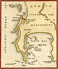 | Details | Naval Chronicle | 1812 |
| Cape of Good Hope with Table Bay and Cape Town. |
|
Naval Chronicle |
|
| 1812 |
| LOC:6 |
| $195.00 | Naval-Chronicle | Cape-of-Good-Hope-with-Table-Bay-and-Cape-Town- | Small attractive antique harbor chart near Cape Town, South Africa showing coastal mountains as well as False Bay and Table Bay. This neat copper-plated engraved antique nautical chart includes the following named features: Penguin Island, Sugar Loaf Hill or the Lion's Head, Lion's Rump, Chapman's or Hout Bay, Simon's Bay, Pringle Bay, Gordons Bay and Cape Hanglip.
<br></br>
Despite its small size the chart has an interesting history. The plate used to create this example was engraved and published by John Luffman in 1801 for Luffman's "Select Plans of the principal cities Ports, Harbours, Forts, etc. in the World". One can see the remnants of Luffman' original imprint mostly erased just below "Cape of Good Hope".
<br></br>
The hydrography includes anchorages, depth soundings, a "best track" into Simons Bay, numerous named rocks in False Bay including Romans Rock, Warren Hastings Rock, Francis Rock, Whittle Rock, and Anvil Rock.
<br></br>
Publisher's imprint at bottom reads: "Published December 31, 1812 by J. Gold. Naval Chronicle Office,103, Show Lane, London." |