| | Thumbnail | | Creator | Date | Title / Author / Date / Location | Price | | | Description |
| 662 | 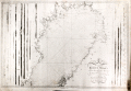 | Details | Nordenankar, Jan | 1790 |
| Chart of Northern Gulf of Bothnia ( Botten Wiken ) |
|
Nordenankar, Jan |
|
| 1790 |
| LOC:0 |
| $1,200.00 | Nordenankar--Jan | Chart-of-Northern-Gulf-of-Bothnia-(-Botten-Wiken-) | Scarce antique Swedish nautical sea chart by Nordenankar of the upper portion of the Gulf of Bothnia with portions of the coasts of Sweden and Finland. Includes these noted cities and features: Umea, Skelleftea, Pitea, Lulea, Tornio, (Tornea), Kemi, Oulu (Uleaborg), Brahestad, Jacobstad, and Kokkola ( Gamla Carleby ).
<br></br>
Produced by Swedish Admiral and cartographer Johan Corvin Nordenankar (1722-1804). Nordenankar, in order to gain major experience at sea early in his career, served in both the English and Maltese navies, participating in a battle between Maltese galleys and an Algerian ship on May 16, 1752. Returning home to Sweden, Nordenankar rose through the ranks of the Swedish navy first as Lieutenant-Commander and later in 1772 served as head of the galley fleet stationed in Stockholm.
<br></br>
Nordenankar is best known for his work as Director of the sjökarteverket, Sweden's nautical chart department, in the 1780's. During his tenure as Director he led the survey and charting of areas that previously were only poorly documented including the Baltic Sea with the Gulf of Bothnia and Gulf of Finland, the Sound, Kattegat and Skagerrak. These areas had become more important militarily to Sweden with Russia's advances into the region and improvements to the cartography of the area had stalled after initial work by Peter Gedda, Nils Power Crona, and Jonas Hahn. Nordenankar work leading the renewed charting of the region resulted in the publication of at least 11 charts under his name. (Reference: sok.riksarkivet.se/SBL/Presentation.aspx?id=8198)
<br></br>
Much hydrographic detail, soundings, and hazards. Left and right portions of the chart contain numerous profile views of the coastline as seen from sea. Engraved by Arkrel. Number 3. |
| 1351 | 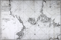 | Details | Nordenankar, Jan | 1800 |
| Scarce antique Swedish sea chart of the Baltic Sea with Stockholm |
|
Nordenankar, Jan |
|
| 1800 |
| LOC:0 |
| $1,600.00 | Nordenankar--Jan | Scarce-antique-Swedish-sea-chart-of-the-Baltic-Sea-with-Stockholm | Scarce antique Swedish nautical chart by Nordenankar of the Upper Baltic Sea and the lower portion of the Gulf of Bothnia. Sweden to the west, Finland to the east, the Aland Islands between the two, dominating the upper Baltic; Estonia in the lower right corner. Includes Stockholm and numerous other cities. Special charts inset include: "Sandhamns Inloop" and "Inloppet til Finska Uto".
<br></br>
Produced by Swedish Admiral and cartographer Johan Corvin Nordenankar (1722-1804). Nordenankar, in order to gain major experience at sea early in his career, served in both the English and Maltese navies, participating in a battle between Maltese galleys and an Algerian ship on May 16, 1752. Returning home to Sweden, Nordenankar rose through the ranks of the Swedish navy first as Lieutenant-Commander and later in 1772 served as head of the galley fleet stationed in Stockholm.
<br></br>
Nordenankar is best known for his work as Director of the sjökarteverket, Sweden's nautical chart department, in the 1780's. During his tenure as Director he led the survey and charting of areas that previously were only poorly documented including the Baltic Sea with the Gulf of Bothnia and Gulf of Finland, the Sound, Kattegat and Skagerrak. These areas had become more important militarily to Sweden with Russia's advances into the region and improvements to the cartography of the area had stalled after intial work by Peter Gedda, Nils Power Crona, and Jonas Hahn. Nordenankar's work leading the renewed charting of the region resulted in the publication of at least 11 charts under his name. (Reference: sok.riksarkivet.se/SBL/Presentation.aspx?id=8198)
<br></br>
Much hydrographic detail, soundings, and hazards. Left and right portions of the chart contain numerous profile views of the coastline as seen from sea. Engraved by Akerlund. Number 5. |