| | Thumbnail | | Creator | Date | Title / Author / Date / Location | Price | | | Description |
| 114 |  | Details | Ogilby, John | 1671 |
| Brasilia |
|
Ogilby, John |
|
| 1671 |
| LOC:0 |
| $0.00 | Ogilby--John | Brasilia | SOLD. .<BR> </BR>
Map of Eastern Brazil published after a work by Arnoldus Montanus. West is shown at top of map. |
| 526 | 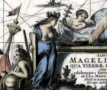 | Details | Ogilby, John | 1671 |
| Tabula Magellanica |
|
Ogilby, John |
|
| 1671 |
| LOC:50 |
| $800.00 | Ogilby--John | Tabula-Magellanica | Very decorative, finely engraved antique map of Cape Horn ( Hoorn ), the southern-most point in South America and the Strait of Magellan, published ca. 1671, about 150 years after Magellan's discovery of the passage.
<br></br>
This original copper-plate engraved map is enlivened by two compass roses, four cartouches and numerous fanciful vignettes including mermaids, ostriches, penguins, and the scene of a sea battle.
<br></br>
This map was published in "America: Being an Accurate Description of the New World…" by John Ogilby, a Scottish cartographer, who was appointed "His Majesty's Cosmographer and Geographic Printer" in 1675. |