| | Thumbnail | | Creator | Date | Title / Author / Date / Location | Price | | | Description |
| 5060 | 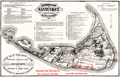 | Details | Old Colony Railroad Company | 1887 |
| Historical Map of Nantucket Surveyed and Drawn by the Rev. F. C. Ewer. D. D. 1869 |
|
Old Colony Railroad Company |
|
| 1887 |
| LOC:0 |
| $0.00 | Old-Colony-Railroad-Company | Historical-Map-of-Nantucket-Surveyed-and-Drawn-by-the-Rev--F--C--Ewer--D--D--1869 | NOT AVAILABLE <br></br>Map of Nantucket Island, 1887 after Reverend F.C. Ewer in 1869. Printed on very thin paper with a section of Nantucket Island identified in red as property of the <b>Nantucket Surf Side Land Co.</b>
<br></br>
Historical Map of Nantucket Surveyed and Drawn by the Rev. F. C. Ewer. D. D. Produced by Old Colony Line "the shortest, quickest, best and only direct route between Boston or New York and Nantucket and Martha's Vineyard." With red ink notations advertising the Nantucket Surf Side Land Company, 46 School Street, Boston, Massachusetts, offering for sale lots for $10 and upwards.
<br></br>
Contains three columns of historical information about Nantucket, arranged chronologically for the seventeenth, eighteenth, and nineteenth centuries. Latest entry is for 1886:
<div class="indenttextblock">
Cable communication with Nantucket by the U.S. Signal Service. Consolidation of the N. & C. C. Steamboat Company with the N. B., V. & Nant. Steamboat Co. with corporate name "New Bedford, Martha's Vineyard and Nantucket Steamboat Company." Steamer Nantucket built by the same Company, and placed upon the route in July.
</div> |