| | Thumbnail | | Creator | Date | Title / Author / Date / Location | Price | | | Description |
| 6387 | 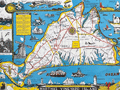 | Details | Parker, Larry | 1955 |
| Pictorial Map of Martha's Vineyard Island, Massachusetts |
|
Parker, Larry |
|
| 1955 |
| LOC:87 |
| $750.00 | Parker--Larry | Pictorial-Map-of-Martha-s-Vineyard-Island--Massachusetts | Original, scarce, 1950's Martha's Vineyard Island, Massachusetts pictorial map by Larry Parker. This lithographed tourist map features bright, bold colors, inset pictorial images of island life, and text blocks of historical facts, all hallmarks of a tourist souvenir map. Slight gloss to the paper finish as typical.
<br></br>
Remarkable condition.
<br></br>
This 1950's era edition is based on Parker's earlier 1935 black and white map of Martha's Vineyard Island. Not only does the new edition feature vivid lithographed color, several changes were made to the content including below the rope-wrapped bollard where the text "Edgartown Harbor" does not appear directly below the bollard. On this colored edition of Parker's map the area is blank. |